IMAGES TAKEN NEAR TO
Vernon Avenue, ELLESMERE PORT, CH66 6AL
Introduction
This page details the photographs taken nearby to Vernon Avenue, CH66 6AL by members of the Geograph project.
The Geograph project started in 2005 with the aim of publishing, organising and preserving representative images for every square kilometre of Great Britain, Ireland and the Isle of Man.

There are currently over 7.5m images from over14,400 individuals and you can help contribute to the project by visiting https://www.geograph.org.uk
Image Map
Images are licensed for reuse under creativecommons.org/licenses/by-sa/2.0
Notes
- Clicking on the map will re-center to the selected point.
- The higher the marker number, the further away the image location is from the centre of the postcode.
Image Listing (14 Images Found)
Images are licensed for reuse under creativecommons.org/licenses/by-sa/2.0
Image
Details
Distance
1
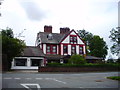
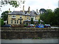
Woodcote House, Hooton
Hotel and restaurant on the B5133 Hooton Road.
Image: © Eirian Evans
Taken: 14 Aug 2011
0.06 miles
2
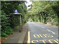
Bus stop and shelter on Hooton Road (B5133)
Image: © JThomas
Taken: 14 Sep 2019
0.14 miles
3
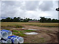
Field of wheat near Hooton
Probably belonging to Chestnut Farm, whose barns (converted) can be seen at the far side of the field.
Image: © Eirian Evans
Taken: 14 Aug 2011
0.15 miles
6
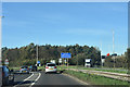
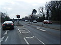
Entering Wirral on A41
Approaching M53 junction 5 roundabout
Image: © John Firth
Taken: 9 Oct 2018
0.18 miles
8
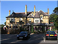
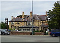
The Chimneys, Hooton
A traditional pub/restaurant on the A41 New Chester Road, near Hooton.
Image: © Eirian Evans
Taken: 14 Aug 2011
0.20 miles
9
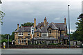
The Chimneys, Hooton
This large Gothic pub on Chester Road has an unusual pedigree in that it began life as a private house, that of David Walker, built for himself c1875 as Plas-y-Groes. Mr Walker was an architect, and it shows.
Image: © Stephen Richards
Taken: 21 Aug 2014
0.20 miles
10

Old Direction Sign - Signpost by the B5133, Hooton Road, Hooton
Lost finial - 1 arm; Cheshire CCC octagonal by the B5133, in parish of Ellesmere Port (Ellesmere Port and Neston District), Hooton Road at junction with School Lane.
Column inscription reads:-
: W.H.SMITH & Co / WHITCHURCH SALOP :
plus a 'CCC' shield.
Plate inscription reads:-
: CHILDER THORNTON :
Surveyed
Milestone Society National ID: CH_SJ3578
Image: © Milestone Society
Taken: Unknown
0.21 miles