1
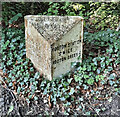
Old Milepost by the A5133, Hooton Road, Hooton
Cast iron post by the A5133, in parish of Neston (Ellesmere Port and Neston District), Hooton Road, West of Hooton Bridge, by the road, on South side of road. Cast iron CCC1898, erected by the County Council in the 19th century.
Inscription reads:-
: WILLASTON / 1½ MILES / NESTON 4½ / PARKGATE 5¾ : : CHESHIRE / 1898 / COUNTY COUNCIL : : HOOTON STATION / ¼ MILE / HOOTON GREEN ½ :
Maker:-
: W H SMITH & CO / MAKERS / WHITCHURCH :
Milestone Society National ID: CH_PGHO05
Image: © Dave Ce
Taken: 22 Sep 2023
0.11 miles
2
Old Milepost by the A5133, Hooton Road, Hooton
Cast iron post by the A5133, in parish of Neston (Ellesmere Port and Neston District), Hooton Road, West of Hooton Bridge, by the road, on South side of road. Cast iron CCC1898, erected by the County Council in the 19th century.
Inscription reads:-
: WILLASTON / 1½ MILES / NESTON 4½ / PARKGATE 5¾ : : CHESHIRE / 1898 / COUNTY COUNCIL : : HOOTON STATION / ¼ MILE / HOOTON GREEN ½ :
Maker:-
: W H SMITH & CO / MAKERS / WHITCHURCH :
Milestone Society National ID: CH_PGHO05
Image: © Gillian Oakes
Taken: 1 Jan 2003
0.11 miles
3
Hooton Road
Image: © Colin Pyle
Taken: 11 Nov 2010
0.12 miles
4
The Hooton
Country pub and restaurant on the B5133, near Hooton railway station.
Image: © Eirian Evans
Taken: 12 May 2016
0.14 miles
5
Hotel
The Hooton hotel.
Image: © Peter Mackenzie
Taken: 15 Mar 2017
0.16 miles
6
The Hooton
Country pub near Hootpon Railway Station.
Currently closed.See
Image] for happier times.
Image: © JThomas
Taken: 14 Sep 2019
0.16 miles
7
The Hooton at Hooton
The Hooton public house situated at the junction of Hooton Road (B5133) and Waterworks Lane.
Update 12/09/21: The Hooton closed in August 2018 and plans have now been submitted which would see the building demolished and 12 houses and six apartments built on the vacant site.
Image: © Jeff Buck
Taken: 30 Aug 2017
0.16 miles
8
The Hooton
Public house, conveniently situated opposite Hooton Station.
Image: © Tiger
Taken: 12 Jun 2010
0.17 miles
9
The Hooton Public House
The Hooton public house at the junction of Hooton Road with Waterworks Lane.
Image: © Sue Adair
Taken: 3 Jun 2006
0.19 miles
10
42537 leaving Hooton Station - 1966
The picture was taken of the locomotive, but is interesting in showing the whole of the former Tragasol works, which produced a variety of vegetable oils. Parts of the building survive in the 21st century, but not the main cross-wing seen here.
Image: © Alan Murray-Rust
Taken: 19 Nov 1966
0.20 miles


