IMAGES TAKEN NEAR TO
Pennington Green, ELLESMERE PORT, CH66 4XJ
Introduction
This page details the photographs taken nearby to Pennington Green, CH66 4XJ by members of the Geograph project.
The Geograph project started in 2005 with the aim of publishing, organising and preserving representative images for every square kilometre of Great Britain, Ireland and the Isle of Man.

There are currently over 7.5m images from over14,400 individuals and you can help contribute to the project by visiting https://www.geograph.org.uk
Image Map (Loading...)


Getting Data...Please wait
Leaflet Map data © OpenStreetMap
Images are licensed for reuse under creativecommons.org/licenses/by-sa/2.0
Notes
- Clicking on the map will re-center to the selected point.
- The higher the marker number, the further away the image location is from the centre of the postcode.
Image Listing (2 Images Found)
Images are licensed for reuse under creativecommons.org/licenses/by-sa/2.0
Image
Details
Distance
1
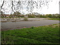
It says School on my OS map! (dated 2000)
Sadly, the concrete bases and abandoned playing courts are all that remain.
Image: © Maggie Cox
Taken: 3 May 2013
0.12 miles
2
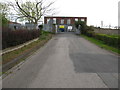
Entrance to the water treatment works
Near Sutton Green
Image: © Maggie Cox
Taken: 3 May 2013
0.25 miles