IMAGES TAKEN NEAR TO
Dolphin Crescent, ELLESMERE PORT, CH66 4UG
Introduction
This page details the photographs taken nearby to Dolphin Crescent, CH66 4UG by members of the Geograph project.
The Geograph project started in 2005 with the aim of publishing, organising and preserving representative images for every square kilometre of Great Britain, Ireland and the Isle of Man.

There are currently over 7.5m images from over14,400 individuals and you can help contribute to the project by visiting https://www.geograph.org.uk
Image Map
Images are licensed for reuse under creativecommons.org/licenses/by-sa/2.0
Notes
- Clicking on the map will re-center to the selected point.
- The higher the marker number, the further away the image location is from the centre of the postcode.
Image Listing (8 Images Found)
Images are licensed for reuse under creativecommons.org/licenses/by-sa/2.0
Image
Details
Distance
2

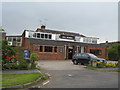
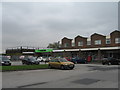
The Straw Hat
Pub with an unusual name.
Image: © Des Blenkinsopp
Taken: 7 Mar 2015
0.14 miles
4
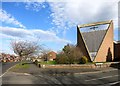
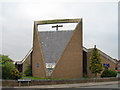
Whitby Methodist Church
A chapel built in 1873 was replaced by this church in 1968.
Image: © Des Blenkinsopp
Taken: 7 Mar 2015
0.23 miles