IMAGES TAKEN NEAR TO
Snowdon Close, ELLESMERE PORT, CH66 4JT
Introduction
This page details the photographs taken nearby to Snowdon Close, CH66 4JT by members of the Geograph project.
The Geograph project started in 2005 with the aim of publishing, organising and preserving representative images for every square kilometre of Great Britain, Ireland and the Isle of Man.

There are currently over 7.5m images from over14,400 individuals and you can help contribute to the project by visiting https://www.geograph.org.uk
Image Map
Images are licensed for reuse under creativecommons.org/licenses/by-sa/2.0
Notes
- Clicking on the map will re-center to the selected point.
- The higher the marker number, the further away the image location is from the centre of the postcode.
Image Listing (6 Images Found)
Images are licensed for reuse under creativecommons.org/licenses/by-sa/2.0
Image
Details
Distance
1
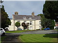
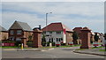
Sutton Hall, Ellesmere Port
Now engulfed by new housing.
Image: © JThomas
Taken: 14 Sep 2019
0.19 miles
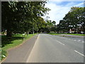
4
Roundabout on Ledsham Road (B5463)
Services a new housing estate - Image]
Image: © JThomas
Taken: 14 Sep 2019
0.23 miles
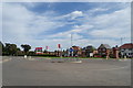
5
Ledsham Garden Village, Ellesmere Port
New housing off Ledsham Road (B5463).
Image: © JThomas
Taken: 14 Sep 2019
0.24 miles
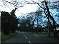
6
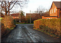
Damp Path
Public footpath meets with the B5463, Little Sutton.
Image: © J Scott
Taken: 19 Nov 2010
0.25 miles