IMAGES TAKEN NEAR TO
Valley Drive, ELLESMERE PORT, CH66 3QA
Introduction
This page details the photographs taken nearby to Valley Drive, CH66 3QA by members of the Geograph project.
The Geograph project started in 2005 with the aim of publishing, organising and preserving representative images for every square kilometre of Great Britain, Ireland and the Isle of Man.

There are currently over 7.5m images from over14,400 individuals and you can help contribute to the project by visiting https://www.geograph.org.uk
Image Map (Loading...)


Getting Data...Please wait
Leaflet Map data © OpenStreetMap
Images are licensed for reuse under creativecommons.org/licenses/by-sa/2.0
Notes
- Clicking on the map will re-center to the selected point.
- The higher the marker number, the further away the image location is from the centre of the postcode.
Image Listing (5 Images Found)
Images are licensed for reuse under creativecommons.org/licenses/by-sa/2.0
Image
Details
Distance
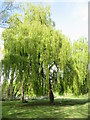
2
Rivacre Valley
This footpath alongside Rivacre Brook continues northwards and opens out into Rivacre Valley Country Park set in over 400 acres of beautiful natural woodlands.
Image: © Sue Adair
Taken: 24 Apr 2012
0.13 miles
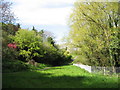
3
Rivacre Brook
The source of the Rivacre Brook is in Capenhurst and it flows through Great Sutton and Overpool before its confluence with the River Mersey at Pool Hall Rocks near the Vauxhall plant.
Image: © Sue Adair
Taken: 24 Apr 2012
0.15 miles
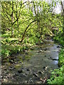
5
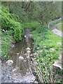
Rivacre Brook
Rivacre Brook from the footbridge near Rossmore Road West.
Image: © Sue Adair
Taken: 24 Apr 2012
0.22 miles