IMAGES TAKEN NEAR TO
Ringway, ELLESMERE PORT, CH66 3LE
Introduction
This page details the photographs taken nearby to Ringway, CH66 3LE by members of the Geograph project.
The Geograph project started in 2005 with the aim of publishing, organising and preserving representative images for every square kilometre of Great Britain, Ireland and the Isle of Man.

There are currently over 7.5m images from over14,400 individuals and you can help contribute to the project by visiting https://www.geograph.org.uk
Image Map (Loading...)


Getting Data...Please wait
Leaflet Map data © OpenStreetMap
Images are licensed for reuse under creativecommons.org/licenses/by-sa/2.0
Notes
- Clicking on the map will re-center to the selected point.
- The higher the marker number, the further away the image location is from the centre of the postcode.
Image Listing (10 Images Found)
Images are licensed for reuse under creativecommons.org/licenses/by-sa/2.0
Image
Details
Distance
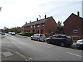
1
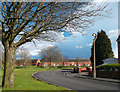
Greasby Drive, Great Sutton
The Rivacre Brook separates this road from the houses beyond.
Image: © Des Blenkinsopp
Taken: 10 Apr 2012
0.09 miles
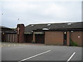
2
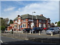
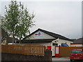
Tesco Express on Sutton Way (B5132), Ellesmere Port
The former Sutton Way public house.
Image: © JThomas
Taken: 14 Sep 2019
0.12 miles
3
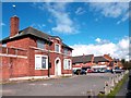
The Sutton Way
Yet another closed pub.
Image: © Des Blenkinsopp
Taken: 10 Apr 2012
0.13 miles
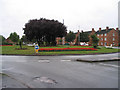
6
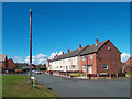
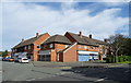
Wilmslow Drive, Great Sutton
At the junction with Alvanley Rd.
Image: © Des Blenkinsopp
Taken: 10 Apr 2012
0.16 miles