IMAGES TAKEN NEAR TO
Chester Road, ELLESMERE PORT, CH66 1QN
Introduction
This page details the photographs taken nearby to Chester Road, CH66 1QN by members of the Geograph project.
The Geograph project started in 2005 with the aim of publishing, organising and preserving representative images for every square kilometre of Great Britain, Ireland and the Isle of Man.

There are currently over 7.5m images from over14,400 individuals and you can help contribute to the project by visiting https://www.geograph.org.uk
Image Map
Images are licensed for reuse under creativecommons.org/licenses/by-sa/2.0
Notes
- Clicking on the map will re-center to the selected point.
- The higher the marker number, the further away the image location is from the centre of the postcode.
Image Listing (17 Images Found)
Images are licensed for reuse under creativecommons.org/licenses/by-sa/2.0
Image
Details
Distance
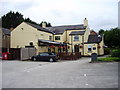
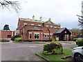
1
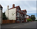
The Halfway House, Childer Thornton
On Chester Road (A41).
Image: © JThomas
Taken: 14 Sep 2019
0.00 miles
2
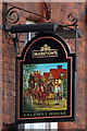
Sign for the Halfway House, Childer Thornton
See Image] for context.
Image: © JThomas
Taken: 14 Sep 2019
0.01 miles
3
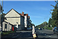
Crossing at New Road junction
Halfway House public House ahead on the left
Image: © John Firth
Taken: 9 Oct 2018
0.01 miles
4
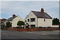
Houses on Chester Road (A41), Childer Thornton
Image: © JThomas
Taken: 14 Sep 2019
0.08 miles
5
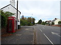
K6 telephone box on Chester Road (A41), Childer Thornton
Image: © JThomas
Taken: 14 Sep 2019
0.08 miles
6
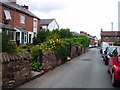
New Road, Childer Thornton
Childer Thornton is a village on the Wirral exactly half way between Chester and Birkenhead.
Image: © Eirian Evans
Taken: 14 Aug 2011
0.08 miles
7
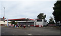
Service station on Chester Road (A41), Childer Thornton
Image: © JThomas
Taken: 14 Sep 2019
0.09 miles
10
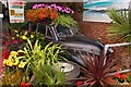
Morris Minor planter at Burleydam Garden Centre
Image: © Steve Daniels
Taken: 29 Jul 2010
0.14 miles