IMAGES TAKEN NEAR TO
Royal Drive, FLINT, CH6 5YA
Introduction
This page details the photographs taken nearby to Royal Drive, CH6 5YA by members of the Geograph project.
The Geograph project started in 2005 with the aim of publishing, organising and preserving representative images for every square kilometre of Great Britain, Ireland and the Isle of Man.

There are currently over 7.5m images from over14,400 individuals and you can help contribute to the project by visiting https://www.geograph.org.uk
Image Map
Images are licensed for reuse under creativecommons.org/licenses/by-sa/2.0
Notes
- Clicking on the map will re-center to the selected point.
- The higher the marker number, the further away the image location is from the centre of the postcode.
Image Listing (2 Images Found)
Images are licensed for reuse under creativecommons.org/licenses/by-sa/2.0
Image
Details
Distance
1
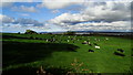
Cows grazing below April Rise Farm near Flint with view across Dee Estuary
Image: © Colin Park
Taken: 16 Oct 2018
0.20 miles
2
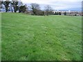
Footpath to Flint
Looking along what appears to be an old hedge line as the maps all seem to indicate woodland here to the left of the path. The footpath stile is to the left of the electricity pole and the field gate is to the right of it.
Image: © John S Turner
Taken: 31 Jan 2007
0.21 miles