1
Flint Footbridge
Footbridge over the railway line near Flint Station, leading to the Kings Christian Centre, the River Dee Community Church housed in the former King's Head public house.
Image: © Roger May
Taken: 22 Aug 2005
0.04 miles
2
Across the Dee to Parkgate
View from Flint castle across the Dee estuary to Parkgate on the Wirral
Image: © Galatas
Taken: 1 Mar 2011
0.04 miles
3
Thurstaston Cliffs viewed from Flint
View across the Dee from Flint castle to Thurstaston Cliffs on the Wirral
Image: © Galatas
Taken: 1 Mar 2011
0.04 miles
4
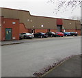
Electricity substation in Castle Park Industrial Estate, Flint
The SP Manweb electricity substation is in the brick enclosure on the left. Its identifier is 07-2473-16 A.P.W.
Image: © Jaggery
Taken: 16 Jan 2017
0.07 miles
5
Jonarve in Flint
Jonarve Ltd packing business is in Unit 10, Castle Park Industrial Estate.
Image: © Jaggery
Taken: 16 Jan 2017
0.08 miles
6
Flint Dock tidal creek
This muddy creek used to be Flint Dock, built in the 1800's to help export Halkyn Mountain lead. Soon after, Flint Marsh Colliery began exporting their coal from here, a timber and boat yard developed beside the leadworks. A chemical works was also built here, making the dock one of the busiest along the Dee.
Image: © Mat Fascione
Taken: 14 Apr 2019
0.09 miles
7
Wales Coast Path
The path crosses this muddy creek on its way north from Flint. This used to be Flint Dock where lead from Halkyn Mountain was exported and later coal too.
Image: © Eirian Evans
Taken: 3 Feb 2012
0.09 miles
8
Stone circle near the Industrial Estate
These look like the gorsedd stones of the National Eisteddfod, but the eisteddfod stones are elsewhere in Flint.
Image: © Eirian Evans
Taken: 3 Feb 2012
0.09 miles
9
Castle Connections in Castle Park Industrial Estate, Flint
Behind the postbox, http://www.geograph.org.uk/photo/5466766 Castle Connections disability information & services office is in Unit 3.
Image: © Jaggery
Taken: 16 Jan 2017
0.10 miles
10
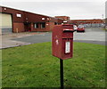
Queen Elizabeth II postbox in Castle Park Industrial Estate, Flint
Located here. http://www.geograph.org.uk/photo/5466763
Image: © Jaggery
Taken: 16 Jan 2017
0.10 miles


