IMAGES TAKEN NEAR TO
Atis Cross, FLINT, CH6 5HA
Introduction
This page details the photographs taken nearby to Atis Cross, CH6 5HA by members of the Geograph project.
The Geograph project started in 2005 with the aim of publishing, organising and preserving representative images for every square kilometre of Great Britain, Ireland and the Isle of Man.

There are currently over 7.5m images from over14,400 individuals and you can help contribute to the project by visiting https://www.geograph.org.uk
Image Map (Loading...)


Getting Data...Please wait
Leaflet Map data © OpenStreetMap
Images are licensed for reuse under creativecommons.org/licenses/by-sa/2.0
Notes
- Clicking on the map will re-center to the selected point.
- The higher the marker number, the further away the image location is from the centre of the postcode.
Image Listing (46 Images Found)
Images are licensed for reuse under creativecommons.org/licenses/by-sa/2.0
Image
Details
Distance
1
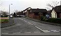
Mill Croft, Flint
Cul-de-sac on the southeast side of Caesar Avenue.
Image: © Jaggery
Taken: 16 Jan 2017
0.04 miles
2
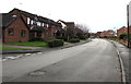
Caesar Avenue, Flint
Looking to the SSW along Caesar Avenue past the corner of Mill Croft.
Image: © Jaggery
Taken: 16 Jan 2017
0.05 miles
3
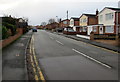
Caesar Avenue, Flint
From the corner of Chester Road.
Image: © Jaggery
Taken: 16 Jan 2017
0.08 miles
4
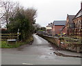
Croes Atti Lane, Oakenholt
Dead-end lane viewed across the A458 Chester Road.
Image: © Jaggery
Taken: 16 Jan 2017
0.09 miles
5
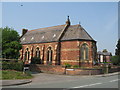
St. David's, Oakenholt
The church of St. David, Oakenholt, was opened in 1872.
Image: © Sue Adair
Taken: 8 May 2008
0.10 miles
6
Julius Close, Flint
Cul-de-sac on the northwest side of Caesar Avenue.
Image: © Jaggery
Taken: 16 Jan 2017
0.11 miles
7
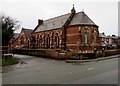
Fenced-off former church and school in Pentre Ffwrndan, Oakenholt
Viewed across the A458 Chester Road in January 2017. The Coflein website states that St David's, Pentre Ffwrndan, was erected as both a church and a school close to the site of an ancient cross. Its purpose was to meet the twin needs of a rapidly increasing population. The building on the corner of Croes Atti Lane opened for divine worship in June 1872. The church closed in January 2011.
Image: © Jaggery
Taken: 16 Jan 2017
0.12 miles
8

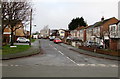
Deeside Shuttle bus in the outskirts of Flint
Heading towards the town centre on the A548 Chester Road.
Image: © Jaggery
Taken: 16 Jan 2017
0.12 miles
9
Flint boundary sign on a lamppost
Facing the A548 Chester Road in the village of Oakenholt.
The Welsh name of the town, here shown as Fflint, is Y Fflint in full.
Image: © Jaggery
Taken: 16 Jan 2017
0.12 miles
10
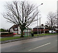
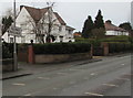
Tree and bus shelter at the SE edge of Flint
Viewed across the A548 Chester Road. The Oakenholt village boundary sign http://www.geograph.org.uk/photo/5255634 is on the right.
Image: © Jaggery
Taken: 16 Jan 2017
0.12 miles