IMAGES TAKEN NEAR TO
Meadow Lane Industrial Park, ELLESMERE PORT, CH65 4TY
Introduction
This page details the photographs taken nearby to Meadow Lane Industrial Park, CH65 4TY by members of the Geograph project.
The Geograph project started in 2005 with the aim of publishing, organising and preserving representative images for every square kilometre of Great Britain, Ireland and the Isle of Man.

There are currently over 7.5m images from over14,400 individuals and you can help contribute to the project by visiting https://www.geograph.org.uk
Image Map (Loading...)


Getting Data...Please wait
Leaflet Map data © OpenStreetMap
Images are licensed for reuse under creativecommons.org/licenses/by-sa/2.0
Notes
- Clicking on the map will re-center to the selected point.
- The higher the marker number, the further away the image location is from the centre of the postcode.
Image Listing (29 Images Found)
Images are licensed for reuse under creativecommons.org/licenses/by-sa/2.0
Image
Details
Distance
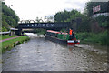
2
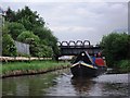
Approaching Ellesmere Port railway bridge on Shropshire Union Canal
The boat in this view is a Josher from the Ellesmere Port museum collection.
Image: © John Brightley
Taken: 14 Jun 2010
0.08 miles
3
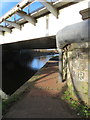
Railway bridge 145A over the Shropshire Union Canal
There is an Ordnance Survey bench mark on the near corner of the bridge support, facing the canal - Image
Image: © John S Turner
Taken: 9 Jan 2019
0.08 miles
4
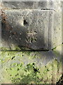
Bench mark on railway bridge 145A over the Shropshire Union Canal
This Ordnance Survey bench mark is on the south east corner of the stone support of railway bridge 145A over the Shropshire Union Canal - Wirral Branch. The cut mark first appears on maps in 1937, but is no longer recorded on the 1967 map. See also Image
Image: © John S Turner
Taken: 9 Jan 2019
0.08 miles
5
Shropshire Union Canal, Ellesmere Port
A narrowboat operated by the National Waterways Museum heads under bridge 145A.
Image: © Stephen McKay
Taken: 10 Sep 2013
0.08 miles
6
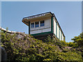
Ellesmere Port No 4 Signal Box
Looking up from the Shropshire Union Canal to the railway signal box above.
Image: © David Dixon
Taken: 25 May 2012
0.08 miles
7
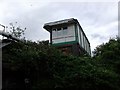
Ellesmere Port No.4 Signal Box
Seen from a boat on the Shropshire Union Canal.
Image: © John Brightley
Taken: 14 Jun 2010
0.08 miles
8
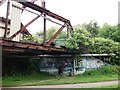
Stanlow Works Access Bridge (disused), Shropshire Union Canal
The name of this girder bridge is taken from the Canal Plan AC website.
Note the supposedly 'official' 'graffiti' with the name of the Prince's Trust Volunteers.
Image: © John Brightley
Taken: 14 Jun 2010
0.08 miles
9
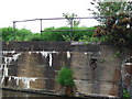
Old wharf on Shropshire Union Canal
Note the old mooring rings in the wall.
Image: © John Brightley
Taken: 14 Jun 2010
0.08 miles
10
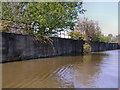
Disused Wharf, Shropshire Union Canal
The disused wharf at the side of the Shropshire Union Canal at the former site of the Burnell & Co works.
Image: © David Dixon
Taken: 25 May 2012
0.09 miles