IMAGES TAKEN NEAR TO
Lime Street, ELLESMERE PORT, CH65 2AZ
Introduction
This page details the photographs taken nearby to Lime Street, CH65 2AZ by members of the Geograph project.
The Geograph project started in 2005 with the aim of publishing, organising and preserving representative images for every square kilometre of Great Britain, Ireland and the Isle of Man.

There are currently over 7.5m images from over14,400 individuals and you can help contribute to the project by visiting https://www.geograph.org.uk
Image Map
Images are licensed for reuse under creativecommons.org/licenses/by-sa/2.0
Notes
- Clicking on the map will re-center to the selected point.
- The higher the marker number, the further away the image location is from the centre of the postcode.
Image Listing (25 Images Found)
Images are licensed for reuse under creativecommons.org/licenses/by-sa/2.0
Image
Details
Distance
2
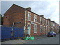
Terraced housing on Elm Street
Mostly taken over for business use.
Image: © JThomas
Taken: 15 Jun 2019
0.09 miles
4
Caf? 59, Ellesmere Port
On Merseyton Road (A5032).
Image: © JThomas
Taken: 15 Jun 2019
0.11 miles
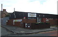
5
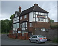
The Grosvenor public house, Ellesmere Port
On Merseyton Road (A5032).
Image: © JThomas
Taken: 15 Jun 2019
0.16 miles
6
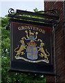
Sign for the Grosvenor public house, Ellesmere Port
Image: © JThomas
Taken: 15 Jun 2019
0.16 miles
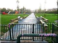
9
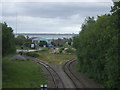
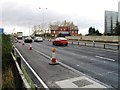
Manchester Ship Canal Railway
View from Merseyton Road bridge on the A5032.
Image: © JThomas
Taken: 15 Jun 2019
0.17 miles
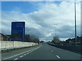
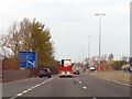
10
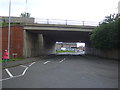
M53 Motorway bridge over the A5032, Ellesmere Port
Image: © JThomas
Taken: 15 Jun 2019
0.18 miles