IMAGES TAKEN NEAR TO
Raby Park Road, NESTON, CH64 9SW
Introduction
This page details the photographs taken nearby to Raby Park Road, CH64 9SW by members of the Geograph project.
The Geograph project started in 2005 with the aim of publishing, organising and preserving representative images for every square kilometre of Great Britain, Ireland and the Isle of Man.

There are currently over 7.5m images from over14,400 individuals and you can help contribute to the project by visiting https://www.geograph.org.uk
Image Map
Images are licensed for reuse under creativecommons.org/licenses/by-sa/2.0
Notes
- Clicking on the map will re-center to the selected point.
- The higher the marker number, the further away the image location is from the centre of the postcode.
Image Listing (19 Images Found)
Images are licensed for reuse under creativecommons.org/licenses/by-sa/2.0
Image
Details
Distance
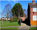
1
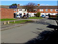
Raleigh Road houses, Neston
Viewed along Grenville Road from the corner of Drake Road.
Image: © Jaggery
Taken: 15 Feb 2018
0.08 miles
2
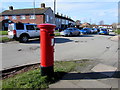
Queen Elizabeth II pillarbox on a Neston corner
On the corner of Grenville Road and Drake Road.
Image: © Jaggery
Taken: 15 Feb 2018
0.10 miles
3
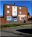
Go Local in Neston
Go Local convenience store at 28 Drake Road is next door to S&N Motor Factors on the corner of Grenville Road.
Image: © Jaggery
Taken: 15 Feb 2018
0.10 miles
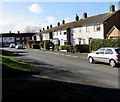
4
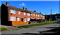
Brick houses, Drake Road, Neston
The roads in this part of Neston, south of Liverpool Road, are named after famous Britons.
Nearby roads include Shakespeare Road, Raleigh Road and Hawkins Road.
Image: © Jaggery
Taken: 15 Feb 2018
0.13 miles
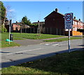
5
Drake Road electricity substation, Neston
In a brick building set back 30 metres from the roadway, near the corner of Liverpool Road.
Image: © Jaggery
Taken: 15 Feb 2018
0.14 miles
6
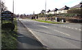
Welcome to Neston - historic market town
The sign faces the B5136 Liverpool Road opposite Mayfield Gardens.
Image: © Jaggery
Taken: 15 Feb 2018
0.16 miles
7
Shakespeare Road, Neston
Viewed from the corner of Drake Road.
Image: © Jaggery
Taken: 15 Feb 2018
0.16 miles
8
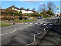
Zebra crossing, Liverpool Road, Neston
Across the B5136 Liverpool Road opposite Mayfield Gardens. Although Belisha beacons had marked pedestrian crossings in the UK from 1934, it was not until 1951 that the now familiar black and white stripes stretching across the width of the road were officially introduced. Previously, there were only metal studs across the road surface.
Image: © Jaggery
Taken: 15 Feb 2018
0.16 miles
9
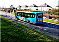
Arriva Merseyside bus, Liverpool Road, Neston
The bus from Liverpool heads towards Neston town centre.
Image: © Jaggery
Taken: 15 Feb 2018
0.16 miles
10
Start of the East Neston 20mph zone
Near a speed bump, the sign alongside Drake Road faces Liverpool Road in Neston.
Image: © Jaggery
Taken: 15 Feb 2018
0.16 miles