IMAGES TAKEN NEAR TO
Olive Drive, NESTON, CH64 9PP
Introduction
This page details the photographs taken nearby to Olive Drive, CH64 9PP by members of the Geograph project.
The Geograph project started in 2005 with the aim of publishing, organising and preserving representative images for every square kilometre of Great Britain, Ireland and the Isle of Man.

There are currently over 7.5m images from over14,400 individuals and you can help contribute to the project by visiting https://www.geograph.org.uk
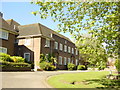
Image Map
Images are licensed for reuse under creativecommons.org/licenses/by-sa/2.0
Notes
- Clicking on the map will re-center to the selected point.
- The higher the marker number, the further away the image location is from the centre of the postcode.
Image Listing (104 Images Found)
Images are licensed for reuse under creativecommons.org/licenses/by-sa/2.0
Image
Details
Distance
2
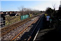
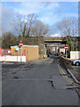
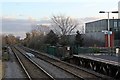
Borderlands Line south of Neston station
Viewed from the southern edge of Neston station https://www.geograph.org.uk/photo/5865158 in Cheshire, England looking along the Borderlands Line which crosses Raby Road bridge in the foreground. The next station ahead, on the route to Wrexham Central in Wales, is Hawarden Bridge near Shotton in Flintshire, Wales.
Image: © Jaggery
Taken: 15 Feb 2018
0.13 miles
3
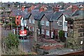
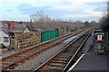
Houses on Raby Road, Neston
As seen from the southern end of the Bidston-bound platform at Neston railway station.
Image: © El Pollock
Taken: 2 Jan 2014
0.14 miles
4
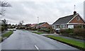
Suburban bungalows, Breezehill Road, Neston
At the eastern edge of this commuter village.
Image: © Christine Johnstone
Taken: 18 Jan 2015
0.14 miles
5
Brook Street, Neston
Looking east along Brook Street towards the railway bridge that carries the Wirral Line between North Wales and Bidston.
Image: © John S Turner
Taken: 14 Feb 2011
0.15 miles
6
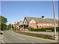
Neston Civic Hall
Neston Civic Hall on Hinderton Road.
Image: © Sue Adair
Taken: 3 Jun 2006
0.15 miles
7
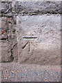
Bench mark on Chester Road bridge
This bench mark is on the north west side of the Chester Road railway bridge abutment. It seems to be a modern mark first shown clearly on the 1968 O.S. map, and possibly on the smaller scale 1954 map. See also Image An earlier mark was recorded on the south east side of the bridge, but that now seems to be lost.
Image: © John S Turner
Taken: 14 Feb 2011
0.15 miles
8
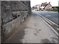
Chester Road and a bench mark
Looking along Chester Road from underneath the railway bridge. There is a bench mark on the left Image
Image: © John S Turner
Taken: 14 Feb 2011
0.15 miles
9
End of platform, Neston railway station
Looking across the railway bridge which traverses Raby Road, the view to the south of the station, from the end of the Wrexham-bound platform.
Image: © El Pollock
Taken: 2 Jan 2014
0.16 miles
10
Raby Road bridge, Neston railway station
At the southern end of the platforms is the railway bridge, which traverses the road.
Image: © El Pollock
Taken: 2 Jan 2014
0.16 miles