IMAGES TAKEN NEAR TO
Chester High Road, NESTON, CH64 7TA
Introduction
This page details the photographs taken nearby to Chester High Road, CH64 7TA by members of the Geograph project.
The Geograph project started in 2005 with the aim of publishing, organising and preserving representative images for every square kilometre of Great Britain, Ireland and the Isle of Man.

There are currently over 7.5m images from over14,400 individuals and you can help contribute to the project by visiting https://www.geograph.org.uk
Image Map
Images are licensed for reuse under creativecommons.org/licenses/by-sa/2.0
Notes
- Clicking on the map will re-center to the selected point.
- The higher the marker number, the further away the image location is from the centre of the postcode.
Image Listing (9 Images Found)
Images are licensed for reuse under creativecommons.org/licenses/by-sa/2.0
Image
Details
Distance

3
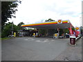
Service station on Chester High Road (A540)
Image: © JThomas
Taken: 15 Jun 2019
0.08 miles
4

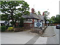
Sign for the Hinderton Arms
Image: © JThomas
Taken: 15 Jun 2019
0.11 miles
5
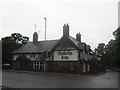
The Hinderton Arms
On Chester High Road (A540).
Image: © JThomas
Taken: 15 Jun 2019
0.12 miles
6

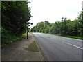
Old Direction Sign - Signpost by the A41, Chester High Road, Neston parish
Pawn finial - 4 arms; Cheshire CCC octagonal (Smith, Whitchurch) by the A540, in parish of Neston (Ellesmere Port and Neston District), Hinderton, opposite Hinderton Arms PH, Chester High Road junction with the B5134 Hinderton Road, and Quarry Road.
Surveyed
Milestone Society National ID: CH_SJ3078
Image: © Milestone Society
Taken: Unknown
0.12 miles
8
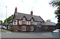
The Hinderton Arms
On Chester High Road (A540).
Image: © JThomas
Taken: 15 Jun 2019
0.13 miles
9
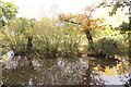
Lees Lane Ponds
The ponds at Lees Lane are at least 150 years old and although some are part of the natural landscape, most were created after marl was dug out by farmers to fertilise the local sandy soils. The ponds and surrounding land are now maintained as a nature reserve.
Friends of Lees Lane Ponds http://neston.org.uk/friends-of-lees-lane-ponds/
Image: © Jeff Buck
Taken: 26 Oct 2016
0.23 miles