IMAGES TAKEN NEAR TO
The Ropewalk, NESTON, CH64 6TJ
Introduction
This page details the photographs taken nearby to The Ropewalk, CH64 6TJ by members of the Geograph project.
The Geograph project started in 2005 with the aim of publishing, organising and preserving representative images for every square kilometre of Great Britain, Ireland and the Isle of Man.

There are currently over 7.5m images from over14,400 individuals and you can help contribute to the project by visiting https://www.geograph.org.uk
Image Map
Images are licensed for reuse under creativecommons.org/licenses/by-sa/2.0
Notes
- Clicking on the map will re-center to the selected point.
- The higher the marker number, the further away the image location is from the centre of the postcode.
Image Listing (117 Images Found)
Images are licensed for reuse under creativecommons.org/licenses/by-sa/2.0
Image
Details
Distance
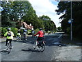
2
In celebration of a vanished railway
This display on the corner of Springcroft and Station Road has a plaque that states:
"In celebration of the
LSNW & GW Joint Railways
Parkgate Branch Line
1866 - 1964"
The embankment behind indicates where the railway once crossed the main road by a bridge on the right.
Image: © John S Turner
Taken: 25 Jan 2009
0.04 miles
3
Station Road
Near Ropewalk with WW2 pillbox in Wirral Way country park.
Image: © Dennis Turner
Taken: 25 May 2009
0.04 miles
4
Station Road
At the junction with Ropewalk, the name of which indicates the activity of rope making which was carried out nearby when Parkgate was a thriving port connecting England with Ireland.
Image: © Dennis Turner
Taken: 25 May 2009
0.04 miles
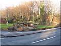
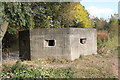
5
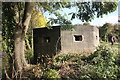
World War II Pillbox, Parkgate
This type 24 pillbox is situated on the south side of Parkgate Road between Parkgate and Neston next to the Wirral Way car park. The pillbox covered the road leading from the River Dee, where the West Kirby to Hooton section of the old Birkenhead Railway crosses.
Source: pastscape.org
Image: © Jeff Buck
Taken: 26 Oct 2016
0.04 miles
6
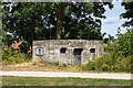
WWII Cheshire: Defences of the Wirral, Parkgate pillbox (1)
-
Pillbox (Type FW3/24): DoB ID: S0006160
Almost all the extant pillboxes on the Wirral have their embrasures and entrances blocked, this example off Station Road, Parkgate being typical. Since photographed by Jeff Buck in 2016 https://www.geograph.org.uk/photo/5202317 it has had louvred panels fitted over some of the embrasures. Situated on high ground in a country park, it covers the road from the Dee Estuary near to where a bridge once carried the old railway line over Station Road.
Image
Image: © Mike Searle
Taken: 25 Jul 2018
0.04 miles
7
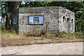
WWII Cheshire: Defences of the Wirral, Parkgate pillbox (2)
-
Pillbox (Type FW3/24): DoB ID: S0006160
Image
Image: © Mike Searle
Taken: 25 Jul 2018
0.04 miles

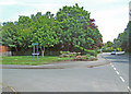
9
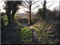
Footpath in the Wirral Country Park
One of the paths linking the Wirral Country Park with the car park.
Image: © John S Turner
Taken: 25 Jan 2009
0.04 miles
10
World War II Pillbox, Parkgate
This type 24 pillbox is situated on the south side of Parkgate Road between Parkgate and Neston next to the Wirral Way car park. The pillbox covered the road leading from the River Dee, where the West Kirby to Hooton section of the old Birkenhead Railway crosses.
Source: pastscape.org
Image: © Jeff Buck
Taken: 26 Oct 2016
0.04 miles