IMAGES TAKEN NEAR TO
Mill Lane, NESTON, CH64 1RE
Introduction
This page details the photographs taken nearby to Mill Lane, CH64 1RE by members of the Geograph project.
The Geograph project started in 2005 with the aim of publishing, organising and preserving representative images for every square kilometre of Great Britain, Ireland and the Isle of Man.

There are currently over 7.5m images from over14,400 individuals and you can help contribute to the project by visiting https://www.geograph.org.uk
Image Map
Images are licensed for reuse under creativecommons.org/licenses/by-sa/2.0
Notes
- Clicking on the map will re-center to the selected point.
- The higher the marker number, the further away the image location is from the centre of the postcode.
Image Listing (8 Images Found)
Images are licensed for reuse under creativecommons.org/licenses/by-sa/2.0
Image
Details
Distance
1

Windmill, Willaston
Mill Lane has been the site of a windmill at Willaston since at least 1321 the surviving Willaston windmill is one of Wirrals tallest and was built in 1800.
Image: © Sue Adair
Taken: 22 May 2004
0.05 miles
2
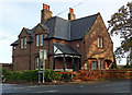
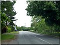
Corner Stone
Sandstone lodge at junction of Mill Lane and Birkenhead Road (B5151).
Image: © J Scott
Taken: 16 Nov 2010
0.06 miles
3
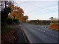
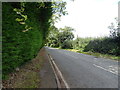
Road Crossing
Junction of Birkenhead Road (B5151) with Lydiate Lane (left) and Mill Lane (right), near Willaston.
Image: © J Scott
Taken: 16 Nov 2010
0.08 miles
8
Old Direction Sign - Signpost by Mill Lane, Willaston
Pawn finial - 1 arm; Wirral Footpath post by the UC road, in parish of Willaston (Chester District), South side of Mill Lane, Willaston, at its junction with the footpath to Willaston, and West of the old windmill.
Column inscription reads:-
: W H SMITH & Co WHITCHURCH :
Plate inscription reads:-
: PUBLIC FOOTPATH TO / WILLASTON / KEEP TO THE PATH :
Surveyed
Milestone Society National ID: CH_SJ3278B
Image: © John S Turner
Taken: 17 Sep 2016
0.24 miles