IMAGES TAKEN NEAR TO
Bathwood Drive, NESTON, CH64 0UR
Introduction
This page details the photographs taken nearby to Bathwood Drive, CH64 0UR by members of the Geograph project.
The Geograph project started in 2005 with the aim of publishing, organising and preserving representative images for every square kilometre of Great Britain, Ireland and the Isle of Man.

There are currently over 7.5m images from over14,400 individuals and you can help contribute to the project by visiting https://www.geograph.org.uk
Image Map
Images are licensed for reuse under creativecommons.org/licenses/by-sa/2.0
Notes
- Clicking on the map will re-center to the selected point.
- The higher the marker number, the further away the image location is from the centre of the postcode.
Image Listing (6 Images Found)
Images are licensed for reuse under creativecommons.org/licenses/by-sa/2.0
Image
Details
Distance
2
Railway bridge over path at Nessholt
Image: © Raymond Knapman
Taken: 4 Apr 2014
0.16 miles
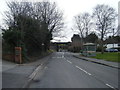
3
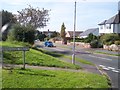
Junction of Greenfields Road and Marshlands Road at Neston
Image: © Raymond Knapman
Taken: 6 Sep 2012
0.18 miles
4
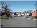
Furrocks Lane
Modern residential area in Nessholt. The road leads down to a railway line beyond which is more residential property down to the Dee marshes.
Image: © Dennis Turner
Taken: 4 Apr 2006
0.22 miles
5
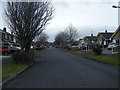
Bull Hill looking towards the railway overbridge
Image: © Colin Pyle
Taken: 28 Feb 2015
0.24 miles
6
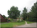
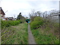
Footpath to the Harp Inn, Little Neston
Image: © John Slater
Taken: 11 Jun 2016
0.25 miles