IMAGES TAKEN NEAR TO
New Street, NESTON, CH64 0TF
Introduction
This page details the photographs taken nearby to New Street, CH64 0TF by members of the Geograph project.
The Geograph project started in 2005 with the aim of publishing, organising and preserving representative images for every square kilometre of Great Britain, Ireland and the Isle of Man.

There are currently over 7.5m images from over14,400 individuals and you can help contribute to the project by visiting https://www.geograph.org.uk
Image Map
Images are licensed for reuse under creativecommons.org/licenses/by-sa/2.0
Notes
- Clicking on the map will re-center to the selected point.
- The higher the marker number, the further away the image location is from the centre of the postcode.
Image Listing (23 Images Found)
Images are licensed for reuse under creativecommons.org/licenses/by-sa/2.0
Image
Details
Distance
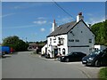
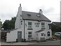
1
Footpath to the Harp Inn, Little Neston
Image: © John Slater
Taken: 11 Jun 2016
0.10 miles
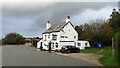
4
Riverside Walk, Little Neston
Close to the river, but not quite the side of the river
Image: © David Smith
Taken: 7 May 2023
0.15 miles
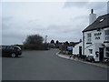
7
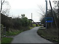
Quayside, south of Denhall Quay, Little Neston
The road is a public footpath, but only residents are allowed to drive past the sign. What lies under the black tape?
Image: © Christine Johnstone
Taken: 2 Feb 2020
0.17 miles