IMAGES TAKEN NEAR TO
Venables Drive, WIRRAL, CH63 9LZ
Introduction
This page details the photographs taken nearby to Venables Drive, CH63 9LZ by members of the Geograph project.
The Geograph project started in 2005 with the aim of publishing, organising and preserving representative images for every square kilometre of Great Britain, Ireland and the Isle of Man.

There are currently over 7.5m images from over14,400 individuals and you can help contribute to the project by visiting https://www.geograph.org.uk
Image Map
Images are licensed for reuse under creativecommons.org/licenses/by-sa/2.0
Notes
- Clicking on the map will re-center to the selected point.
- The higher the marker number, the further away the image location is from the centre of the postcode.
Image Listing (7 Images Found)
Images are licensed for reuse under creativecommons.org/licenses/by-sa/2.0
Image
Details
Distance
1
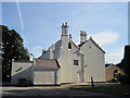
Poulton Hey
Originally the dower house of the Lancelyn Green family, built in 1843, but never used for this purpose, the house was used for church groups from 1968 until given to the parish of St Andrews by Roger Lancelyn Green in 1972. The Lancelyn family coat of arms features three stags and is visible on the right gable. In 1977 it was dedicated as a church itself and fulfilled this role until 1987 when the new building was erected. It is now the parish centre.
Image: © Sue Adair
Taken: 6 Sep 2012
0.08 miles
2
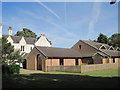
Holy Trinity Church, Poulton
In 1977, prior to the opening of this church, the adjoining house Poulton Hey, which had been used for church groups since 1968, was given by Sir Roger Lancelyn Green and dedicated as a church itself. A daughter church to the ancient St Andrew's in Bebington it fulfilled this role until the new building was erected.
The foundation stone of the new church was laid on February 1st 1987 by Sir Roger Lancelyn Green and was opened on September 1st of the same year. It has subsequently become a separate parish with its own vicar and vicarage and a large and thriving church community.
Image: © Sue Adair
Taken: 6 Sep 2012
0.08 miles
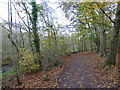
3
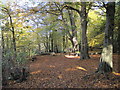
Bromborough Wood in Autumn
Bromborough Wood in Autumn, a footpath around Brotherton Park and Dibbinsdale Local Nature Reserve.
Image: © Sue Adair
Taken: 27 Oct 2012
0.22 miles
5
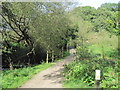
Footpath and footbridge over the River Dibbin
Footpath and Ladybridge over the River Dibbin, a Nature Reserve of semi-natural countryside along the river valley. Many different wildlife habitats are represented within the reserve including ancient woodland, willow carr, reed beds and wild flower meadows.
Image: © Sue Adair
Taken: 6 Sep 2012
0.23 miles
7
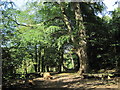
Autumn scene in Dibbinsdale
The river can be seen on left
Image: © Raymond Knapman
Taken: 31 Oct 2014
0.25 miles