IMAGES TAKEN NEAR TO
Woodhey Road, WIRRAL, CH63 8PD
Introduction
This page details the photographs taken nearby to Woodhey Road, CH63 8PD by members of the Geograph project.
The Geograph project started in 2005 with the aim of publishing, organising and preserving representative images for every square kilometre of Great Britain, Ireland and the Isle of Man.

There are currently over 7.5m images from over14,400 individuals and you can help contribute to the project by visiting https://www.geograph.org.uk
Image Map (Loading...)


Getting Data...Please wait
Leaflet Map data © OpenStreetMap
Images are licensed for reuse under creativecommons.org/licenses/by-sa/2.0
Notes
- Clicking on the map will re-center to the selected point.
- The higher the marker number, the further away the image location is from the centre of the postcode.
Image Listing (11 Images Found)
Images are licensed for reuse under creativecommons.org/licenses/by-sa/2.0
Image
Details
Distance
2
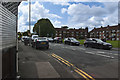
Bus stop on Old Chester Road, Rock Ferry
Image: © Eirian Evans
Taken: 17 Nov 2010
0.16 miles
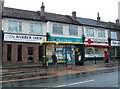
4
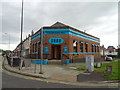
Zuzu Turkish Bar & Grill, Bebington
On Old Chester Road.
Image: © JThomas
Taken: 15 Jun 2019
0.20 miles
5
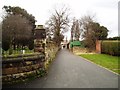
Townfield Lane Footpath
The boundary walls of Bebington Cemetery run along this footpath. Known locally as the cinder path, now resurfaced by the council. This path runs along the back of the grandstand at the Oval Sports Centre, which is situated behind the photographer position.
Image: © Mihacel
Taken: 23 Feb 2003
0.20 miles
8
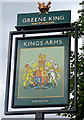
Sign for the Kings Arms, Bebington
See Image] for context.
Image: © JThomas
Taken: 15 Jun 2019
0.21 miles
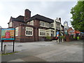
9

Power House
Electricity substation in the mock Victorian style.
Image: © J Scott
Taken: 22 Mar 2007
0.22 miles