IMAGES TAKEN NEAR TO
Rocklands Avenue, WIRRAL, CH63 7LJ
Introduction
This page details the photographs taken nearby to Rocklands Avenue, CH63 7LJ by members of the Geograph project.
The Geograph project started in 2005 with the aim of publishing, organising and preserving representative images for every square kilometre of Great Britain, Ireland and the Isle of Man.

There are currently over 7.5m images from over14,400 individuals and you can help contribute to the project by visiting https://www.geograph.org.uk
Image Map (19 Images)


Getting Data...Please wait
Leaflet Map data © OpenStreetMap
Images are licensed for reuse under creativecommons.org/licenses/by-sa/2.0
Notes
- Clicking on the map will re-center to the selected point.
- The higher the marker number, the further away the image location is from the centre of the postcode.
Image Listing (19 Images Found)
Images are licensed for reuse under creativecommons.org/licenses/by-sa/2.0
Image
Details
Distance
1
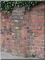
Weathered bench mark at #88 Highfield South
There is an Ordnance Survey bench mark on the buttress of this wall, next to the drive of #88 Highfield South.
Image: © John S Turner
Taken: 21 Mar 2016
0.09 miles
2
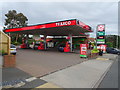
Service station on Old Chester Road, Bebington
Image: © JThomas
Taken: 15 Jun 2019
0.13 miles
4
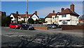
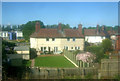
Housing in Woodhey
Large detached homes are typical of this prosperous district.
Image: © Peter Mackenzie
Taken: 15 Mar 2017
0.15 miles
6
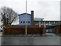
St John Plessington Catholic College
The current school site was originally St John's High School. After a merger with Rock Ferry Convent in the early 1980s it became Plessington High School. In 2010, the school won the prestigious TES "Secondary School of the Year" award.
Image: © Eirian Evans
Taken: 17 Nov 2010
0.17 miles
7
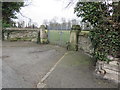
Gateway in Highfield South
This locked gateway provides access to the school playing fields from Highfield South. There is an Ordnance Survey bench mark at the base of the far gatepost - Image
Image: © John S Turner
Taken: 21 Mar 2016
0.19 miles
8
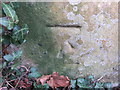
Weathered bench mark in Highfield South
This weathered bench mark is on a gatepost set back in a semi-circle from Highfield South. Image Image
Image: © John S Turner
Taken: 21 Mar 2016
0.19 miles
9
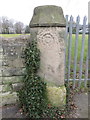
Weathered gatepost in Highfield South
This weathered gatepost is set back from Highfield South. The 'smiley face' at the top of the post seems to have been caused by the weathering of the original design. There is an Ordnance Survey bench mark at the foot of the post - Image
Image: © John S Turner
Taken: 21 Mar 2016
0.19 miles
10
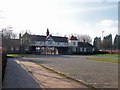
Gateway to Bebington Oval Sports Centre
The running track here was used in the filming of 'Chariots of Fire'
Image: © Sue Morgan
Taken: 18 Feb 2006
0.19 miles