IMAGES TAKEN NEAR TO
Peter Prices Lane, WIRRAL, CH63 2PG
Introduction
This page details the photographs taken nearby to Peter Prices Lane, CH63 2PG by members of the Geograph project.
The Geograph project started in 2005 with the aim of publishing, organising and preserving representative images for every square kilometre of Great Britain, Ireland and the Isle of Man.

There are currently over 7.5m images from over14,400 individuals and you can help contribute to the project by visiting https://www.geograph.org.uk
Image Map
Images are licensed for reuse under creativecommons.org/licenses/by-sa/2.0
Notes
- Clicking on the map will re-center to the selected point.
- The higher the marker number, the further away the image location is from the centre of the postcode.
Image Listing (4 Images Found)
Images are licensed for reuse under creativecommons.org/licenses/by-sa/2.0
Image
Details
Distance
1
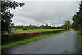
Brackenwood Road, Bromborough
A rather dull picture, but taken for a reason which may since have been nullified.
This general area is a possible location of one of the most momentous and blood-soaked battles of Anglo-Saxon England, the Battle of Brunanburh in 937. The forces of Athelstan, King of England, defeated an alliance of the kings of Dublin, Scotland, and Strathclyde. After the battle, Athelstan became the most powerful man to rule in Britain since the Romans.
The location of the battle has been much debated and has still not been identified. Bromborough's claim appears to rest on the name alone, but one piece of research pinpointed the area now covered by the golf course seen here on the left. However, it is still very much up for grabs, with, for example, the historian Michael Wood favouring a site near York.
Image: © Stephen Richards
Taken: 20 Aug 2014
0.20 miles
2
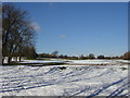
Brackenwood Golf Course
Brackenwood Golf Course, course closed! What a waste of a lovely winter Saturday
Image: © Sue Adair
Taken: 4 Mar 2006
0.20 miles
3
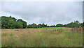
Golf course, Brackenwood Road, Bromborough
A rather dull picture, but taken for a reason which may since have been nullified.
This general area is a possible location of one of the most momentous and blood-soaked battles of Anglo-Saxon England, the Battle of Brunanburh in 937. The forces of Athelstan, King of England, defeated an alliance of the kings of Dublin, Scotland, and Strathclyde. After the battle, Athelstan became the most powerful man to rule in Britain since the Romans.
The location of the battle has been much debated and has still not been identified. Bromborough's claim appears to rest on the name alone, but one piece of research pinpointed the area now covered by the golf course seen here. However, it is still very much up for grabs, with, for example, the historian Michael Wood favouring a site near York.
Image: © Stephen Richards
Taken: 20 Aug 2014
0.24 miles
4
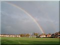
Over the posts!
This rainbow was converted whilst walking past the Wirral Grammar School for Boys rugby fields, the shot taken from Stanton Road, Bebington
Image: © Peter Bruffell
Taken: 13 Nov 2005
0.24 miles