IMAGES TAKEN NEAR TO
Grange Drive, WIRRAL, CH63 1JH
Introduction
This page details the photographs taken nearby to Grange Drive, CH63 1JH by members of the Geograph project.
The Geograph project started in 2005 with the aim of publishing, organising and preserving representative images for every square kilometre of Great Britain, Ireland and the Isle of Man.

There are currently over 7.5m images from over14,400 individuals and you can help contribute to the project by visiting https://www.geograph.org.uk
Image Map
Images are licensed for reuse under creativecommons.org/licenses/by-sa/2.0
Notes
- Clicking on the map will re-center to the selected point.
- The higher the marker number, the further away the image location is from the centre of the postcode.
Image Listing (53 Images Found)
Images are licensed for reuse under creativecommons.org/licenses/by-sa/2.0
Image
Details
Distance
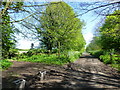
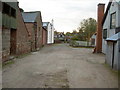
1
Private Road/Footpath near Thornton Hough
The road leads off from one of the Thornton Manor drives and acts as a driveway for a few houses and a farm. The road is also part of a public footpath to Brimstage.
Image: © David Quinn
Taken: 1 Nov 2008
0.05 miles
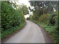
2
Grange Drive near Thornton Hough
A path crosses the drive leading to Brimstage
Image: © Raymond Knapman
Taken: 10 May 2018
0.05 miles
3
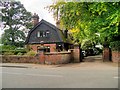
Hesketh Grange Lodge
The South Lodge to Hesketh Grange Manor, which was built in 1894 for Lord Leverhulme's father. The lodge, on Manor Road, is a Grade II listed building (English Heritage Building ID: 215480 http://www.britishlistedbuildings.co.uk/en-215480-south-lodge-to-hesketh-grange-#.VfG98XmFOHs British Listed Buildings).
Image: © David Dixon
Taken: 6 Sep 2015
0.06 miles
4
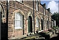
Thornton Hough
Sandstone almshouses right on the southern boundary of a square.
Image: © Rosalind Mitchell
Taken: 19 Oct 2002
0.08 miles
5
Farm Road in Thornton Hough
The road acts as a drive for the farm, and also as the beginning of a public footpath to Brimstage.
Image: © David Quinn
Taken: 1 Nov 2008
0.11 miles
6
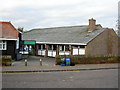
Thornton Hough Village Hall
The main building on the right is the village hall; the black building on the left is part of the same complex, but houses a pre-school.
Image: © David Quinn
Taken: 1 Nov 2008
0.11 miles
7
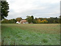
Fields and Farm north of Thornton Hough
Taken from the footpath.
Image: © David Quinn
Taken: 1 Nov 2008
0.12 miles
8
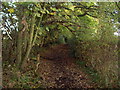
Footpath to Brimstage
A short footpath to Brimstage from Thornton Hough. From here the footpath crosses fields parallel to Manor Road before joining a public bridleway.
Image: © David Quinn
Taken: 1 Nov 2008
0.12 miles
9
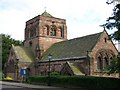
St. George's Church, Thornton Hough
Built by William Lever & opened in 1907. Situated between the three roads of St. George's Way, Manor Road & Thornton Common Road.
Image: © El Pollock
Taken: 23 Jul 2009
0.12 miles
10
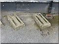
Cycle stands at Thornton Hough Village Hall
One would have hoped that the wheel-bending "concrete slot" type of cycle stand had long been superseded by frame-supporting ("Sheffield" type) stands. But apparently not. This is clearly a relatively modern installation; it incorporates two concessions to present-day needs - an extra slot has been incorporated to accept wider mountain-bike type tyres and a ring to accept cable locks has been included.
Image: © Oliver Dixon
Taken: 4 Jun 2014
0.13 miles