IMAGES TAKEN NEAR TO
Grassmoor Close, WIRRAL, CH62 7JY
Introduction
This page details the photographs taken nearby to Grassmoor Close, CH62 7JY by members of the Geograph project.
The Geograph project started in 2005 with the aim of publishing, organising and preserving representative images for every square kilometre of Great Britain, Ireland and the Isle of Man.

There are currently over 7.5m images from over14,400 individuals and you can help contribute to the project by visiting https://www.geograph.org.uk
Image Map (Loading...)


Getting Data...Please wait
Leaflet Map data © OpenStreetMap
Images are licensed for reuse under creativecommons.org/licenses/by-sa/2.0
Notes
- Clicking on the map will re-center to the selected point.
- The higher the marker number, the further away the image location is from the centre of the postcode.
Image Listing (21 Images Found)
Images are licensed for reuse under creativecommons.org/licenses/by-sa/2.0
Image
Details
Distance
3
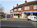
Bromborough Post Office
The post office on Bromborough High Street.
Image: © David Dixon
Taken: 3 Mar 2011
0.15 miles
4
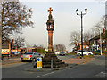
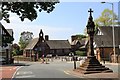
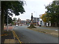
Bromborough Cross
The market cross was the traditional centre of Bromborough village and also an assembly point for local farm labourers available for hire. The steps of the cross are from the original 13th century monument. The cross itself is a more recent reproduction.
Image: © David Dixon
Taken: 3 Mar 2011
0.18 miles
5
Old Central Cross by The Rake, Bromborough
Bromborough Market Cross, old base and steps in a new cross, by the wayside, in parish of Bebington (Wirral District), The Rake, at junction with Allport Lane, on paved area.
Grade II* listed.
List Entry Number: 1075384 https://historicengland.org.uk/listing/the-list/list-entry/1075384
Surveyed
Milestone Society National ID: MSWI_BEB02
Image: © Milestone Society
Taken: Unknown
0.18 miles
6
Memorial cross in Bromborough village
Image: © Raymond Knapman
Taken: 31 Oct 2014
0.18 miles
7
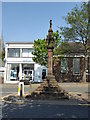
Bromborough Village Cross
The market cross was the traditional centre of the village and also an assembly point for local farm labourers available for hire. The steps of the cross are from the original 13th-century monument. The cross itself is a more recent reproduction, presented to the town by the Bromborough Society.
Image: © Eirian Evans
Taken: 12 May 2016
0.18 miles
8
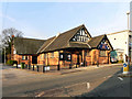
Bromborough Church Institute
The Bromborough Church Institute building, in front of St Barnabas' Church.
Image: © David Dixon
Taken: 3 Mar 2011
0.19 miles
9
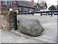
Old Boundary Marker by Bromborough Primary School, Bebington Parish
Parish Boundary Marker by the UC road, in parish of Bebington (Wirral District), Bromborough Primary School, in gap in wall, by pavement.
Surveyed
Milestone Society National ID: CH_BRBE01pb
Image: © Milestone Society
Taken: Unknown
0.20 miles
10
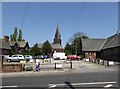
Church Lane, Bromborough
Parking area for St Barnabas Church and church buildings.
Image: © Eirian Evans
Taken: 12 May 2016
0.20 miles