IMAGES TAKEN NEAR TO
Boundary Road, WIRRAL, CH62 5ET
Introduction
This page details the photographs taken nearby to Boundary Road, CH62 5ET by members of the Geograph project.
The Geograph project started in 2005 with the aim of publishing, organising and preserving representative images for every square kilometre of Great Britain, Ireland and the Isle of Man.

There are currently over 7.5m images from over14,400 individuals and you can help contribute to the project by visiting https://www.geograph.org.uk
Image Map
Images are licensed for reuse under creativecommons.org/licenses/by-sa/2.0
Notes
- Clicking on the map will re-center to the selected point.
- The higher the marker number, the further away the image location is from the centre of the postcode.
Image Listing (33 Images Found)
Images are licensed for reuse under creativecommons.org/licenses/by-sa/2.0
Image
Details
Distance
1
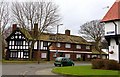
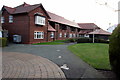
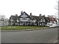
Houses, Port Sunlight
At the north end of the garden village.Light and open spaces were considered very important for his tenants and workforce, by Lord Leverhulme.
In 1887,William Lever, as he was then,bought 56 acres of land on the Wirral in Cheshire between the River Mersey and the railway line at Bebington. This site became Port Sunlight where he built his works and a model village to house its employees. From 1888, Port Sunlight village offered decent living conditions in the belief that good housing would ensure a healthy and happy workforce.
Image: © Peter Barr
Taken: 5 Nov 2012
0.06 miles
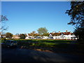
2

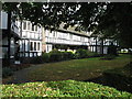
A small open space in Port Sunlight model village
Image: © Ian Greig
Taken: 28 Jul 2017
0.08 miles
3
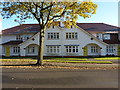
Central Road, Port Sunlight
A terrace of four cottages, of stunning design, in the garden village, designed by one of a team of 30 architects for Lord Leverhulme to house some of the work-force of his soap factory.
Image: © Peter Barr
Taken: 5 Nov 2012
0.13 miles
4
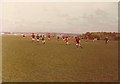
Mayfields, New Ferry, April 1976
The playing fields these Under-13s were playing on was previously a brickworks up until the 1950s. The "hill" to the right is an uncompleted landfill (it remains to this day uncompleted!) The current view from this location includes a further higher uncompleted landfill behind the landfill in this picture. To think that landfills are supposed to be converted to parks and open spaces within a year of their termination of landfill operations makes one think aghastly toward the local council. This area is one of the most deprived of the borough and to this day local Councillors still ignore it!
Image: © Mihacel
Taken: 11 Apr 1976
0.15 miles
6
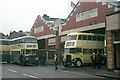
Birkenhead Corporation Motor Omnibus Garage
This was the Corporation's secondary garage at New Ferry, built in the 1930s. Sadly it has now been demolished and replaced by commercial development.
In this view buses of the former Birkenhead Corporation and Wallasey Corporation bus fleets can be seen, by now operated by Merseyside PTE. The blue bus is in the PTE's Wirral division livery, representing the blue of Birkenhead with the cream of Wallasey (neither accurate continuations!). The cream bus is a former Wallasey bus and was on a special tour saying farewell after some 20 years of service. It was repainted specially and has been preserved. It is shown here as if working on the old service 10 which was operated jointly by the two undertakings, running between New Ferry and New Brighton. A feature of both Birkenhead and Wallasey buses was the very large and clear destination display.
This is one of a series of views featuring buses in the 60s, 70s, and 80s. http://www.geograph.org.uk/search.php?i=2114547&displayclass=slide
Image: © Alan Murray-Rust
Taken: 28 Jan 1973
0.20 miles
7
Houses at Port Sunlight.
Port Sunlight is a model village and 'Conservation Area' on the Wirral Peninsula between Lower Bebington and New Ferry. Construction began in 1888; today the village comprises 900 Grade II listed buildings.
Named after the popular brand of "Sunlight Soap", Port Sunlight was built by William Hesketh Lever (later Lord Leverhulme) for the employees of Lever Brothers soap factory (now part of Unilever). Lever personally helped to plan the village and employed nearly thirty different architects in its design. Between 1899 and 1914, 800 houses with a population of 3,500 were built, together with allotments and public buildings, including the Lady Lever Art Gallery, a cottage hospital, schools, a concert hall, open air swimming pool, church, and a temperance hotel. Lever also introduced schemes for welfare, education and the entertainment of his workers, and encouraged recreation and organisations which promoted art, literature, science or music.
Port Sunlight Village is a delightful place to stroll around, and its Lady Lever Art Gallery and nearby Museum are well worth visiting.
Image: © Gerald Massey
Taken: 1 Aug 2008
0.20 miles
8
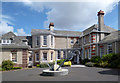
The Leverhulme Hotel
Originally a cottage hospital, opened in 1907 as part of Lord Leverhulme's model town.
Following restoration it re-opened as a hotel in 2008.
Image: © Des Blenkinsopp
Taken: 12 Aug 2013
0.21 miles
9
Timber framed houses, Port Sunlight
A corner terrace of several timber frame fronted houses in the Port Sunlight model village. The terrace is grade II listed. https://www.historicengland.org.uk/listing/the-list/list-entry/1075453
Image: © Graham Robson
Taken: 12 Mar 2016
0.21 miles