IMAGES TAKEN NEAR TO
Croft Green, WIRRAL, CH62 3LL
Introduction
This page details the photographs taken nearby to Croft Green, CH62 3LL by members of the Geograph project.
The Geograph project started in 2005 with the aim of publishing, organising and preserving representative images for every square kilometre of Great Britain, Ireland and the Isle of Man.

There are currently over 7.5m images from over14,400 individuals and you can help contribute to the project by visiting https://www.geograph.org.uk
Image Map
Images are licensed for reuse under creativecommons.org/licenses/by-sa/2.0
Notes
- Clicking on the map will re-center to the selected point.
- The higher the marker number, the further away the image location is from the centre of the postcode.
Image Listing (18 Images Found)
Images are licensed for reuse under creativecommons.org/licenses/by-sa/2.0
Image
Details
Distance
1
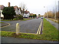
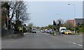
Terraced properties in Magazine Road Bromborough
Image: © Peter Holmes
Taken: 1 Mar 2010
0.07 miles
3
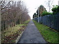
Footpath linking Magazine Road and Magazine Lane
Image: © Peter Holmes
Taken: 1 Mar 2010
0.11 miles
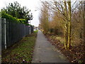
6
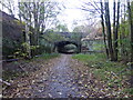
A41 road bridge in Bromborough
The bridge crosses a dismantled railway which once served Port Sunlight Soap Works. Now converted to a cycle way.
Image: © Raymond Knapman
Taken: 31 Oct 2014
0.11 miles
8
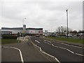
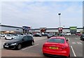
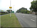
Welton Road, Bromborough
Welton Road bisects the Croft Retail Park in Bromborough.
Image: © Graham Robson
Taken: 12 Mar 2016
0.17 miles
9
Footpath from Magazine Road to Stadium Road
Image: © Peter Holmes
Taken: 1 Mar 2010
0.17 miles