
IMAGES TAKEN NEAR TO
Churchwood Close, WIRRAL, CH62 2DS
Introduction
This page details the photographs taken nearby to Churchwood Close, CH62 2DS by members of the Geograph project.
The Geograph project started in 2005 with the aim of publishing, organising and preserving representative images for every square kilometre of Great Britain, Ireland and the Isle of Man.

There are currently over 7.5m images from over14,400 individuals and you can help contribute to the project by visiting https://www.geograph.org.uk
Image Map
Images are licensed for reuse under creativecommons.org/licenses/by-sa/2.0
Notes
- Clicking on the map will re-center to the selected point.
- The higher the marker number, the further away the image location is from the centre of the postcode.
Image Listing (38 Images Found)
Images are licensed for reuse under creativecommons.org/licenses/by-sa/2.0
Image
Details
Distance
1
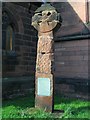
Cross at St Barnabas Church
The sign on the cross says "TO THE GLORY OF GOD THESE FRAGMENTS OF A SAXON CROSS EVIDENCE OF A CHRISTIAN COMMUNITY IN BROMBOROUGH A THOUSAND YEARS AGO WERE RE-ERECTED BY THE BROMBOROUGH SOCIETY IN 1958."
However, other sources state this is a Viking cross. Personally, I think it looks Celtic.
Image: © Peter Craine
Taken: 11 Feb 2007
0.10 miles
3
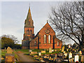
St Barnabas' Church, Bromborough
St Barnabas' Church at Bromborough is a Grade II listed building. It was built between 1862 and 1864.
The first church on the site was built in 928 adjacent to a monastery. This church was demolished in 1828 and replaced on the same site by another church. This church was again replaced by the present church.
Image: © David Dixon
Taken: 3 Mar 2011
0.12 miles
4
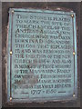
Plaque, St Barnabas' Church
Plaque in the graveyard of St Barnabas' Church This marks the position of the chancel of the Anglo Saxon church which was demolished in 1828 to make way for the new building which was itself replaced in 1864 by the present church.
Image: © Sue Adair
Taken: 1 Feb 2011
0.12 miles
5
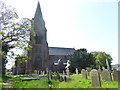
St Barnabas church, Bromborough
Church and churchyard from the north
Image: © Eirian Evans
Taken: 12 May 2016
0.12 miles
6
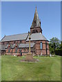
St Barnabas Church, Bromborough
The church from the south, and war memorial for the First World War.
Image: © Eirian Evans
Taken: 12 May 2016
0.12 miles
7
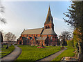
St Barnabas' Church
St Barnabas' Church at Bromborough is a Grade II listed building. It was built between 1862 and 1864.
The first church on the site was built in 928 adjacent to a monastery. This church was demolished in 1828 and replaced on the same site by another church. This church was again replaced by the present church.
Image: © David Dixon
Taken: 3 Mar 2011
0.12 miles
8
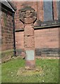
Old Central Cross - moved to St Barnabas Parish churchyard, Bromborough
St Barnabas Bromborough Cross, old head and shaft in a new cross by the churchyard path, in parish of Bebington (Wirral District), St Barnabas parish churchyard, Bromborough, beside church porch.
Grade II listed. List Entry Number: 1343465
https://historicengland.org.uk/listing/the-list/list-entry/1343465
Surveyed
Milestone Society National ID: MSWI_BEB03.
Image: © Milestone Society
Taken: Unknown
0.13 miles
9
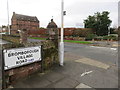
Junction of Bromborough Village Road and Mark Rake
The junction of Bromborough Village road, and the unusually named road Mark Rake. There is a milestone set into the wall between the road sign and the lamppost, which states 'Chester 11 Miles'. It also has a bench mark - see Image
Image: © John S Turner
Taken: 1 Dec 2015
0.13 miles
10
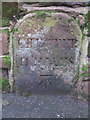
Milestone - Chester 11 Miles and a bench mark
This milestone with a bench mark is built into the car park wall outside 'The Bromborough' public house. See also Image
Image: © John S Turner
Taken: 1 Dec 2015
0.13 miles