IMAGES TAKEN NEAR TO
Samaria Avenue, WIRRAL, CH62 1HE
Introduction
This page details the photographs taken nearby to Samaria Avenue, CH62 1HE by members of the Geograph project.
The Geograph project started in 2005 with the aim of publishing, organising and preserving representative images for every square kilometre of Great Britain, Ireland and the Isle of Man.

There are currently over 7.5m images from over14,400 individuals and you can help contribute to the project by visiting https://www.geograph.org.uk
Image Map
Images are licensed for reuse under creativecommons.org/licenses/by-sa/2.0
Notes
- Clicking on the map will re-center to the selected point.
- The higher the marker number, the further away the image location is from the centre of the postcode.
Image Listing (17 Images Found)
Images are licensed for reuse under creativecommons.org/licenses/by-sa/2.0
Image
Details
Distance
2
Bus stop and shelter on Shorefields, New Ferry
Image: © JThomas
Taken: 15 Jun 2019
0.08 miles
7
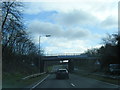
New Ferry Road bridge over New Ferry Bypass
With a banner carrying a safety message
Image: © David Smith
Taken: 28 Apr 2024
0.19 miles
8
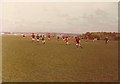
Mayfields, New Ferry, April 1976
The playing fields these Under-13s were playing on was previously a brickworks up until the 1950s. The "hill" to the right is an uncompleted landfill (it remains to this day uncompleted!) The current view from this location includes a further higher uncompleted landfill behind the landfill in this picture. To think that landfills are supposed to be converted to parks and open spaces within a year of their termination of landfill operations makes one think aghastly toward the local council. This area is one of the most deprived of the borough and to this day local Councillors still ignore it!
Image: © Mihacel
Taken: 11 Apr 1976
0.20 miles
9
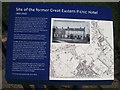
Site of The Great Eastern Hotel
Information board at the site of The Great Eastern Hotel. There are now houses built on the site.
Image: © Sue Adair
Taken: 24 Nov 2017
0.20 miles
10
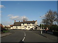
The Great Eastern, New Ferry
Built in 1862 to serve Liverpool daytrippers from New Ferry pier this inn was located at the junction of New Ferry Road with Shorefields. The SS Great Eastern was a ship designed by Isambard Kingdom Brunel and the public house was named to celebrate its launch. She was the largest ship ever built at the time of her 1858 launch and had the capacity to carry 4,000 passengers around the world without refuelling. She was broken up for scrap on the shore at adjacent Rock Ferry in 1889–1890 and many items from the ship were bought by the then landlord and displayed in the pub. The mast was floated across the Mersey to Liverpool from where it was hauled up Everton Valley by a team of four horses and put in place at the Kemlyn Road corner of the Kop stands at Anfield where it stood for many years as a flagpole.
The pub closed soon after this photograph was taken in 2007 and despite a local campaign to get the building listed, it was demolished in 2010 and houses built on the site.
Image: © Sue Adair
Taken: 17 Jan 2007
0.20 miles