IMAGES TAKEN NEAR TO
Park West, WIRRAL, CH60 9JE
Introduction
This page details the photographs taken nearby to Park West, CH60 9JE by members of the Geograph project.
The Geograph project started in 2005 with the aim of publishing, organising and preserving representative images for every square kilometre of Great Britain, Ireland and the Isle of Man.

There are currently over 7.5m images from over14,400 individuals and you can help contribute to the project by visiting https://www.geograph.org.uk
Image Map (Loading...)


Getting Data...Please wait
Leaflet Map data © OpenStreetMap
Images are licensed for reuse under creativecommons.org/licenses/by-sa/2.0
Notes
- Clicking on the map will re-center to the selected point.
- The higher the marker number, the further away the image location is from the centre of the postcode.
Image Listing (14 Images Found)
Images are licensed for reuse under creativecommons.org/licenses/by-sa/2.0
Image
Details
Distance
1
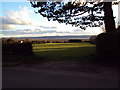
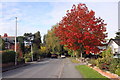
Late evening view, Lower Heswall
Late evening view from Davenport Road, Lower Heswall across fields to the marshes and Welsh Hills. Taken 13/03/2011
Image: © Tom Stapledon
Taken: 13 Mar 2011
0.09 miles
3
Marine Drive on the Dee estuary at Heswall
Image: © Raymond Knapman
Taken: 2 Sep 2011
0.12 miles
4
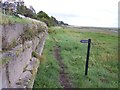
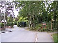
Signpost for path up to Park West
Path from Riverbank Road follows the edge of the salt marsh
Image: © Raymond Knapman
Taken: 2 Sep 2011
0.13 miles
5
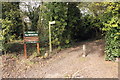
The entrance to Wirral Way at Davenport Road
Wirral Way follows the trackbed of the West Kirby to Hooton railway line
Image: © Raymond Knapman
Taken: 2 Sep 2011
0.13 miles
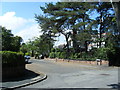
6
The Wirral Way at Davenport Road, Heswall
The Wirral Way leaves leaves the former railway trackbed and follows Davenport Road for a while.
Wikipedia https://en.wikipedia.org/wiki/Wirral_Country_Park
Image: © Jeff Buck
Taken: 21 Oct 2016
0.14 miles
7
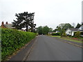
Davenport Road
The Wirral Way - looking north west.
The disused railway has been built on here.
Image: © JThomas
Taken: 25 May 2019
0.14 miles
8
Entrance to the Wirral Way off Davenport Road
Entrance to the Wirral Way off Davenport Road at Heswall.
Wikipedia https://en.wikipedia.org/wiki/Wirral_Country_Park
Image: © Jeff Buck
Taken: 21 Oct 2016
0.14 miles
9
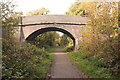
The Wirral Way at Farr Hall Drive Bridge
The Wirral Way heading northwest at Heswall.
Wikipedia https://en.wikipedia.org/wiki/Wirral_Country_Park
Image: © Jeff Buck
Taken: 21 Oct 2016
0.16 miles
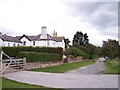
10
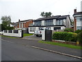
Houses on Davenport Road
The disused railway has been built on here.
Image: © JThomas
Taken: 25 May 2019
0.17 miles