IMAGES TAKEN NEAR TO
Oldfield Way, WIRRAL, CH60 6RJ
Introduction
This page details the photographs taken nearby to Oldfield Way, CH60 6RJ by members of the Geograph project.
The Geograph project started in 2005 with the aim of publishing, organising and preserving representative images for every square kilometre of Great Britain, Ireland and the Isle of Man.

There are currently over 7.5m images from over14,400 individuals and you can help contribute to the project by visiting https://www.geograph.org.uk
Image Map (Loading...)


Getting Data...Please wait
Leaflet Map data © OpenStreetMap
Images are licensed for reuse under creativecommons.org/licenses/by-sa/2.0
Notes
- Clicking on the map will re-center to the selected point.
- The higher the marker number, the further away the image location is from the centre of the postcode.
Image Listing (5 Images Found)
Images are licensed for reuse under creativecommons.org/licenses/by-sa/2.0
Image
Details
Distance
3
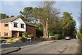
Corner of Quarry Road East and Erica Court, Heswall
The new housing on the left is built on the old quarry site
Image: © Sue Morgan
Taken: 15 Feb 2006
0.22 miles
4
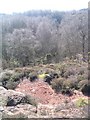
Rocky outcrop at Heswall Dales
See Image The rock is Triassic sandstone.
Image: © Peter Craine
Taken: 17 Feb 2007
0.22 miles
5
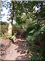
Step Up
Steps along the Heswall Dales footpath leading to top of hills and beyond to Oldfield Road
Image: © J Scott
Taken: 13 Oct 2010
0.24 miles