IMAGES TAKEN NEAR TO
Mill Lane, WIRRAL, CH60 2TQ
Introduction
This page details the photographs taken nearby to Mill Lane, CH60 2TQ by members of the Geograph project.
The Geograph project started in 2005 with the aim of publishing, organising and preserving representative images for every square kilometre of Great Britain, Ireland and the Isle of Man.

There are currently over 7.5m images from over14,400 individuals and you can help contribute to the project by visiting https://www.geograph.org.uk
Image Map
Images are licensed for reuse under creativecommons.org/licenses/by-sa/2.0
Notes
- Clicking on the map will re-center to the selected point.
- The higher the marker number, the further away the image location is from the centre of the postcode.
Image Listing (12 Images Found)
Images are licensed for reuse under creativecommons.org/licenses/by-sa/2.0
Image
Details
Distance
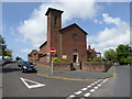
3
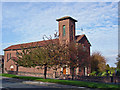
Heswall - church of Our Lady and St. John
Heswall: Roman Catholic church of Our Lady & St John (built in 1919) on Telegraph Road.
Image: © Mike Harris
Taken: 29 Oct 2006
0.18 miles
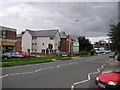
6
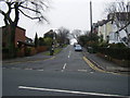
Telegraph Road (A540), Heswall
Towards Hoylake.
Image: © JThomas
Taken: 15 Jun 2019
0.22 miles
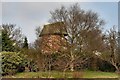
7
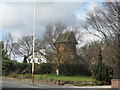
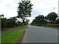
Gayton Windmill
The remains of Gayton's windmill which stopped operating in 1875.
Image: © Sue Adair
Taken: 29 Mar 2007
0.23 miles
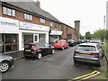
8
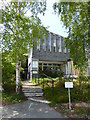
The Olive Grove restaurant on Telegraph Road Heswall
Image: © Raymond Knapman
Taken: 6 Sep 2012
0.23 miles