IMAGES TAKEN NEAR TO
Barnston Road, WIRRAL, CH60 1UB
Introduction
This page details the photographs taken nearby to Barnston Road, CH60 1UB by members of the Geograph project.
The Geograph project started in 2005 with the aim of publishing, organising and preserving representative images for every square kilometre of Great Britain, Ireland and the Isle of Man.

There are currently over 7.5m images from over14,400 individuals and you can help contribute to the project by visiting https://www.geograph.org.uk
Image Map (Loading...)


Getting Data...Please wait
Leaflet Map data © OpenStreetMap
Images are licensed for reuse under creativecommons.org/licenses/by-sa/2.0
Notes
- Clicking on the map will re-center to the selected point.
- The higher the marker number, the further away the image location is from the centre of the postcode.
Image Listing (17 Images Found)
Images are licensed for reuse under creativecommons.org/licenses/by-sa/2.0
Image
Details
Distance
1
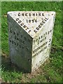
Old Milepost by the A551, Barnston Road, Heswall
Cast iron post by the A551, in parish of HESWALL (WIRRAL District), Barnston, on grass, on East side of road. Cast iron CCC1896, erected by the County Council in the 19th century.
Inscription reads:-
: GAYTON / ¼ MILE / NESTON 3½ : : CHESHIRE / 1896 / COUNTY COUNCIL : : BARNSTON / ¾ MILE / WOODCHURCH 3 / BIRKENHEAD 7 :
Maker:-
: W H SMITH & CO / MAKER / WHITCHURCH :
Milestone Society National ID: CH_BHNS07
Image: © J Higgins
Taken: 1 Jul 2004
0.03 miles
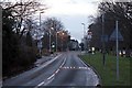
2
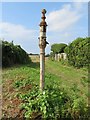
Old Direction Sign - Signpost by the A551, Barnston Road, Heswall
Lost finial - lost arms; Cheshire CCC octagonal by the A551, in parish of Heswall (Wirral District), Barnston Road opposite junction with Acre Lane.
Surveyed
Milestone Society National ID: CH_SJ2882A
Image: © John S Turner
Taken: 7 Sep 2016
0.06 miles
3
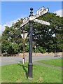
Old Direction Sign - Signpost by the A551, Barnston Road, Heswall
Pawn finial - 3 arms; Cheshire CCC octagonal by the A551, in parish of Heswall (Wirral District), junction of Barnston Road with Whitehouse Lane.
Column inscription reads:- : W H SMITH Co / WHITCHURCH (SALOP) :
Plus 'CCC' shield.
Surveyed
Milestone Society National ID: CH_SJ2882B
Image: © John S Turner
Taken: 7 Sep 2016
0.07 miles
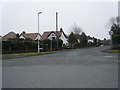
6
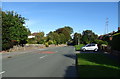
Whitehouse Lane, Heswall
Towards Brimstage.
Image: © JThomas
Taken: 14 Sep 2019
0.18 miles
7
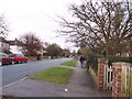
Whitehouse Lane, Heswall
Bridge in the distance carrying Bidston to Chester railway line
Image: © Sue Morgan
Taken: 15 Feb 2006
0.19 miles
8
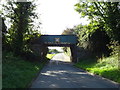
Railway bridge over Whitehouse Lane
The line from Bidston to Wrexham.
Image: © JThomas
Taken: 14 Sep 2019
0.22 miles
9
A5137 Brimstage Road, Heswall
Outside Heswall railway station, looking in the direction of Gayton roundabout.
Image: © El Pollock
Taken: 2 Jan 2014
0.24 miles
10
The derelict ticket office of Heswall Hills railway station on Brimstage Road
The office was used for the former named Heswall Hills station
Image: © Raymond Knapman
Taken: 2 Sep 2011
0.24 miles