IMAGES TAKEN NEAR TO
Dee View Road, WIRRAL, CH60 0DW
Introduction
This page details the photographs taken nearby to Dee View Road, CH60 0DW by members of the Geograph project.
The Geograph project started in 2005 with the aim of publishing, organising and preserving representative images for every square kilometre of Great Britain, Ireland and the Isle of Man.

There are currently over 7.5m images from over14,400 individuals and you can help contribute to the project by visiting https://www.geograph.org.uk
Image Map
Images are licensed for reuse under creativecommons.org/licenses/by-sa/2.0
Notes
- Clicking on the map will re-center to the selected point.
- The higher the marker number, the further away the image location is from the centre of the postcode.
Image Listing (38 Images Found)
Images are licensed for reuse under creativecommons.org/licenses/by-sa/2.0
Image
Details
Distance
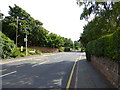
1
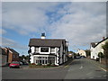
Dee View Inn, Heswall
Dee View Inn, Heswall from the junction of The Mount and Dee View Road
Image: © Sue Adair
Taken: 16 Oct 2010
0.06 miles
2
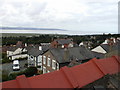
Rooftop view of Lower Heswall
A rooftop view of Lower Heswall with the Dee View Inn in the foreground and looking towards the mouth of the Dee estuary and North Wales. Taken from the junction of Dawstone Road and Rocky Lane. Taken 26-08-2006
Image: © Tom Stapledon
Taken: 22 Aug 2006
0.09 miles
5
Thurstaston Road at junction with Herbert's Lane
Image: © Raymond Knapman
Taken: 28 Aug 2013
0.13 miles
6

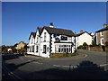
The Dee View, Heswall
This pub occupies an unusual location on a hair-pin bend that takes The Mount down into Dee View Road. The pub dates from the late 19th century and does indeed offer an excellent view of the Dee estuary.
Image: © Stephen McKay
Taken: 5 Apr 2018
0.14 miles
7
Post box and mobile phone mast, Lower Heswall
Image: © Richard Human
Taken: 7 Apr 2006
0.14 miles
8
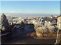
The Dee View Inn and war memorial, Lower Heswall
The Dee View Inn and war memorial with view across Lower Heswall to the Welsh Hills obscured by a low rolling mist. Taken 6/12/2010
Image: © Tom Stapledon
Taken: 6 Dec 2010
0.14 miles
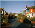
9

Dee View Road, Heswall
At the top of Dee View Road is this hair-pin bend leading round into The Mount. Ahead is Rocky Lane and to the right Dawstone Road. Motorists are aided by a large mirror, just out of shot to the right. The building on the immediate left, with the satellite dish, is the Dee View pub.
Image: © Stephen McKay
Taken: 5 Apr 2018
0.14 miles
10
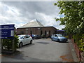
United Reformed Church, Heswall
Tucked in behind The Mount.
Image: © Eirian Evans
Taken: 17 May 2016
0.14 miles