IMAGES TAKEN NEAR TO
Green Lane, Ewloe Green, DEESIDE, CH5 3BR
Introduction
This page details the photographs taken nearby to Green Lane, Ewloe Green, CH5 3BR by members of the Geograph project.
The Geograph project started in 2005 with the aim of publishing, organising and preserving representative images for every square kilometre of Great Britain, Ireland and the Isle of Man.

There are currently over 7.5m images from over14,400 individuals and you can help contribute to the project by visiting https://www.geograph.org.uk
Image Map
Images are licensed for reuse under creativecommons.org/licenses/by-sa/2.0
Notes
- Clicking on the map will re-center to the selected point.
- The higher the marker number, the further away the image location is from the centre of the postcode.
Image Listing (6 Images Found)
Images are licensed for reuse under creativecommons.org/licenses/by-sa/2.0
Image
Details
Distance
1
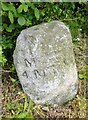
Old Milestone by the B5127, Ewloe Green, Hawarden Parish
By the B5127 (was A494), in parish of Hawarden (Flintshire District), Ewloe Green, between primary school and Old Liverpool Road on verge, South side of road.
Inscription reads:- : MOLD / 4 MILES : : QUEENSFERRY / 2 / MILES :
Surveyed
Milestone Society National ID: FLT_MDQF04
Image: © Milestone Society
Taken: Unknown
0.11 miles
2
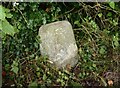
Old Milestone by the B5127, Ewloe Green, Hawarden Parish
By the B5127 (was A494), in parish of Hawarden (Flintshire District), Ewloe Green, between primary school and Old Liverpool Road on verge, South side of road.
Inscription reads:- : MOLD / 4 MILES : : QUEENSFERRY / 2 / MILES :
Surveyed
Milestone Society National ID: FLT_MDQF04
Image: © Christopher Leather
Taken: 27 Jul 2024
0.11 miles
3
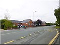
Ewloe Green, primary school
Ewloe Green C.P. School / Ysgol Ewloe Green, on Mold Road. http://www.ewloegreen.co.uk/aboutus.html
Image: © Mike Faherty
Taken: 17 May 2012
0.15 miles
4
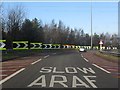
Slow for the trumpet
Signs and road markings indicate the tight turns required to get from A55 to A494 eastbound. This junction is a very late (1984) example of the "trumpet" style of free-flow road junction, much favoured in 1960s UK motorway building, but rapidly disfavoured due to the tight curves inherent in its design. Although free-flow design is generally preferred, in this instance it is arguably a mistake, since this junction's construction gave rise to three intersections within one mile on a 70mph road with layouts which mean "weaving" between conflicting traffic flows is inevitable. A roundabout here with "collector lanes" between Ewloe and the A494 western junction (A55 33a) might well have been a safer and equally efficient design. For more information on styles of road junction commonly employed and their merits or failings, see: http://www.cbrd.co.uk/interchanges/
Image: © Peter Whatley
Taken: 18 Jan 2011
0.22 miles
5
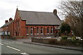
The Presbyterian Church at Ewloe Green
Beside the B5127
Image: © David Long
Taken: 6 Mar 2006
0.24 miles
6
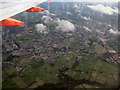
The very distinctive interchange at Ewloe
Seen from an easyJet Airbus inbound from Lisbon to Liverpool. Rain streaks on the window obscure some detail but Buckley is discernible
Image: © David J Smith
Taken: 15 Oct 2008
0.25 miles