IMAGES TAKEN NEAR TO
Brookleigh Avenue, DEESIDE, CH5 2BB
Introduction
This page details the photographs taken nearby to Brookleigh Avenue, CH5 2BB by members of the Geograph project.
The Geograph project started in 2005 with the aim of publishing, organising and preserving representative images for every square kilometre of Great Britain, Ireland and the Isle of Man.

There are currently over 7.5m images from over14,400 individuals and you can help contribute to the project by visiting https://www.geograph.org.uk
Image Map
Images are licensed for reuse under creativecommons.org/licenses/by-sa/2.0
Notes
- Clicking on the map will re-center to the selected point.
- The higher the marker number, the further away the image location is from the centre of the postcode.
Image Listing (11 Images Found)
Images are licensed for reuse under creativecommons.org/licenses/by-sa/2.0
Image
Details
Distance
1

Daleside Garden Centre, Hawarden
Daleside Garden Centre on Gladstone Way, Hawarden.
Image: © Jeff Buck
Taken: 18 Apr 2014
0.14 miles
2

Christmas display at Daleside Garden Centre
These Father Christmas figures were lined up for sale at the Garden Centre
Image: © David and Rachel Landin
Taken: 26 Nov 2021
0.14 miles

4

Gladstone Way, Hawarden
Gladstone Way (A550) looking south, taken from the entrance to Daleside Garden Centre.
Image: © Jeff Buck
Taken: 18 Apr 2014
0.15 miles
5
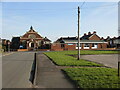
Mancott Presbyterian Church and church hall
Looking along Mancot Lane towards Mancott Presbyterian Church and church hall. For some reason the church and the village names are spelt differently; also since this photo was taken in 2013 houses have been built on the former library car park on the right. There is an Ordnance Survey benchmark on the right hand corner of the church: Image
Image: © John S Turner
Taken: 17 Feb 2013
0.16 miles
6

Gladstone Way, Hawarden
Gladstone Way (A550) heading north, taken from opposite the entrance to Daleside Garden Centre.
Image: © Jeff Buck
Taken: 18 Apr 2014
0.16 miles
7

Benchmark on Mancott Presbyterian Church, Mancot
Ordnance Survey benchmark on the south west corner of Mancott Presbyterian Church. For some reason the church and the village names are spelt differently. The benchmark was levelled at 20.410m above Newlyn Datum some time after the church was built in 1928. For a view of the church see: Image
Benchmark Database: https://www.bench-marks.org.uk/bm223916
Image: © John S Turner
Taken: 17 Feb 2013
0.17 miles
8

Gladstone Way, Big Mancot
Looking north on the A550 towards Queensferry.
Image: © JThomas
Taken: 25 May 2019
0.17 miles

10
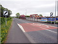
A550 outside Daleside Garden Centre
Looking along the A550 in the direction of Queensferry from opposite the entrance to Daleside Garden Centre.
Image: © John S Turner
Taken: 29 Apr 2010
0.17 miles