IMAGES TAKEN NEAR TO
Aston Park Road, DEESIDE, CH5 1UB
Introduction
This page details the photographs taken nearby to Aston Park Road, CH5 1UB by members of the Geograph project.
The Geograph project started in 2005 with the aim of publishing, organising and preserving representative images for every square kilometre of Great Britain, Ireland and the Isle of Man.

There are currently over 7.5m images from over14,400 individuals and you can help contribute to the project by visiting https://www.geograph.org.uk
Image Map
Images are licensed for reuse under creativecommons.org/licenses/by-sa/2.0
Notes
- Clicking on the map will re-center to the selected point.
- The higher the marker number, the further away the image location is from the centre of the postcode.
Image Listing (3 Images Found)
Images are licensed for reuse under creativecommons.org/licenses/by-sa/2.0
Image
Details
Distance
1
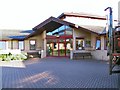
Deeside Community Hospital
The main entrance to the Hospital, at Higher Shotton, Deeside.
Image: © Roger May
Taken: 25 Aug 2005
0.06 miles
2
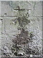
Benchmark on Shotton Lane railway bridge, Higher Shotton
Ordnance Survey benchmark on Shotton Lane railway bridge, which seems to be covered in hardened lime that has leached out of the old mortar. The mark was levelled at 25.366m above Newlyn Datum, verified in 1959. For a wider view see Image
Benchmark Database: https://www.bench-marks.org.uk/bm205214
Image: © John S Turner
Taken: 25 Jun 2016
0.20 miles
3
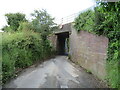
Shotton Lane railway bridge, Higher Shotton
Shotton Lane railway bridge, Higher Shotton has an Ordnance Survey benchmark on the right side/south west wall Image
Image: © John S Turner
Taken: 25 Jun 2016
0.20 miles