IMAGES TAKEN NEAR TO
Chester Business Park, CHESTER, CH4 9FB
Introduction
This page details the photographs taken nearby to CH4 9FB by members of the Geograph project.
The Geograph project started in 2005 with the aim of publishing, organising and preserving representative images for every square kilometre of Great Britain, Ireland and the Isle of Man.

There are currently over 7.5m images from over14,400 individuals and you can help contribute to the project by visiting https://www.geograph.org.uk
Image Map
Images are licensed for reuse under creativecommons.org/licenses/by-sa/2.0
Notes
- Clicking on the map will re-center to the selected point.
- The higher the marker number, the further away the image location is from the centre of the postcode.
Image Listing (6 Images Found)
Images are licensed for reuse under creativecommons.org/licenses/by-sa/2.0
Image
Details
Distance
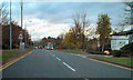
1

Herons Way/Sandpiper Way Roundabout, Chester Business Park
Image: © David Dixon
Taken: 9 Nov 2010
0.12 miles
3

A tree giving a splash of colour on the bank of the cutting
On the left is part of the very long slip road eastbound onto the Chester bypass from the A483
Image: © David Smith
Taken: 23 Apr 2015
0.14 miles
4
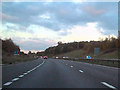
A55 Near Eccleston
The Chester Bypass (A55), near Eccleston (at the point where the inside lane merges).
Image: © David Dixon
Taken: 9 Nov 2010
0.16 miles
5
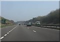
Extended slip road on the Chester bypass
Both entrance and exit slip roads to the east of the A483 interchange are extremely long, easily exceeding one kilometre.
Image: © Peter Whatley
Taken: 23 Mar 2012
0.19 miles
6
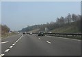
A55 Chester bypass near Half Moon plantation
The exceedingly long slip lane from the A483 ends just ahead.
Image: © Peter Whatley
Taken: 23 Mar 2012
0.24 miles