IMAGES TAKEN NEAR TO
Houghton Road, WIRRAL, CH49 8JQ
Introduction
This page details the photographs taken nearby to Houghton Road, CH49 8JQ by members of the Geograph project.
The Geograph project started in 2005 with the aim of publishing, organising and preserving representative images for every square kilometre of Great Britain, Ireland and the Isle of Man.

There are currently over 7.5m images from over14,400 individuals and you can help contribute to the project by visiting https://www.geograph.org.uk
Image Map (Loading...)


Getting Data...Please wait
Leaflet Map data © OpenStreetMap
Images are licensed for reuse under creativecommons.org/licenses/by-sa/2.0
Notes
- Clicking on the map will re-center to the selected point.
- The higher the marker number, the further away the image location is from the centre of the postcode.
Image Listing (5 Images Found)
Images are licensed for reuse under creativecommons.org/licenses/by-sa/2.0
Image
Details
Distance
1
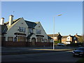
The Pelican, Woodchurch Estate
Boarded up, its upper windows smashed, the derelict public house "The Pelican" situated in Houghton Road, Woodchurch estate
Image: © Sue Adair
Taken: 13 Nov 2005
0.04 miles
3
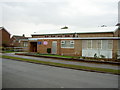
Woodchurch Community Centre Methodist Church
The church has helped fund the building of some residential blocks just to the right of the photograph.
Image: © David Quinn
Taken: 22 Dec 2007
0.20 miles
4
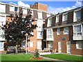
Wesley Grange
Sheltered Housing Scheme belonging to Wirral Methodist Housing Association Ltd.
Image: © Christine M Williams
Taken: 1 Sep 2004
0.21 miles
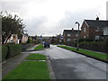
5
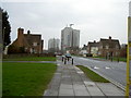
Woodchurch Estate
A typical view of the Woodchurch estate, a large housing estate that has completely engulfed the former Woodchurch hamlet. There use to be more tower blocks, such as those in the picture, on the Upton by-pass, but these were torn down.
Image: © David Quinn
Taken: 22 Dec 2007
0.24 miles