IMAGES TAKEN NEAR TO
Ackers Road, WIRRAL, CH49 7LE
Introduction
This page details the photographs taken nearby to Ackers Road, CH49 7LE by members of the Geograph project.
The Geograph project started in 2005 with the aim of publishing, organising and preserving representative images for every square kilometre of Great Britain, Ireland and the Isle of Man.

There are currently over 7.5m images from over14,400 individuals and you can help contribute to the project by visiting https://www.geograph.org.uk
Image Map (Loading...)


Getting Data...Please wait
Leaflet Map data © OpenStreetMap
Images are licensed for reuse under creativecommons.org/licenses/by-sa/2.0
Notes
- Clicking on the map will re-center to the selected point.
- The higher the marker number, the further away the image location is from the centre of the postcode.
Image Listing (12 Images Found)
Images are licensed for reuse under creativecommons.org/licenses/by-sa/2.0
Image
Details
Distance
1
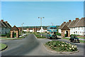
Ackers Road, Woodchurch
Woodchurch Estate was Birkenhead's prestige large council estate development in the post war period. This was the entrance to the estate with its attractive pair of lodges at the entrance from Woodchurch Road. The bus will have made a circuit of the estate and is now heading back to the Woodside ferry terminal.
This is one of a series of views featuring buses in the 60s, 70s, and 80s. http://www.geograph.org.uk/search.php?i=2114547&displayclass=slide
Image: © Alan Murray-Rust
Taken: 15 May 1966
0.10 miles
2
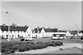
Home Farm Road, Woodchurch ? 1966
Woodchurch Estate was the first and largest of Birkenhead's post-WW2 housing estates, commenced in 1946, and designed with plenty of open space, particularly along the main arteries like Home Farm Road.
Image: © Alan Murray-Rust
Taken: 14 May 1966
0.14 miles

8
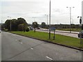
Over and Under
The point at which the A552 from Arrowe Park begins to fly-over the M53 at junction 3 near Woodchurch.
Image: © Roger May
Taken: 30 Aug 2005
0.20 miles
9

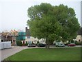
Terraced houses on Common Field Road, Prenton
Image: © Eirian Evans
Taken: 23 May 2016
0.21 miles