IMAGES TAKEN NEAR TO
Arrowe Park Road, WIRRAL, CH49 5LW
Introduction
This page details the photographs taken nearby to Arrowe Park Road, CH49 5LW by members of the Geograph project.
The Geograph project started in 2005 with the aim of publishing, organising and preserving representative images for every square kilometre of Great Britain, Ireland and the Isle of Man.

There are currently over 7.5m images from over14,400 individuals and you can help contribute to the project by visiting https://www.geograph.org.uk
Image Map
Images are licensed for reuse under creativecommons.org/licenses/by-sa/2.0
Notes
- Clicking on the map will re-center to the selected point.
- The higher the marker number, the further away the image location is from the centre of the postcode.
Image Listing (27 Images Found)
Images are licensed for reuse under creativecommons.org/licenses/by-sa/2.0
Image
Details
Distance
1
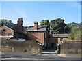
Ivy Farm, Arrowe Park Road
Ivy Farm, Arrowe Park Road, now used as a visitor centre for the park.
Image: © Sue Adair
Taken: 23 Oct 2007
0.02 miles
2
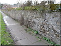
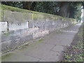
Stone wall alongside Arrowe Park Road
This stone wall runs alongside Arrowe Park Road and bounds the historic Arrowe Park. There is an Ordnance Survey bench mark at the base of the wall nearest the camera - Image
Image: © John S Turner
Taken: 30 Mar 2018
0.05 miles
3
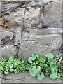
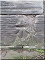
Bench mark in Arrowe Park Road, opposite Landican Cemetery
This Ordnance Survey bench mark is on the long wall bounding Arrowe Park, and is opposite the end of a stone wall in front of Landican Cemetery. See also Image
Image: © John S Turner
Taken: 30 Mar 2018
0.06 miles
4
Stone wall in Arrowe Park Road, Woodchurch
This stone wall is alongside Arrowe Park Road and opposite Landican Cemetery. There is an Ordnance Survey bench mark near the base of the wall nearest the camera. Image
Image: © John S Turner
Taken: 30 Mar 2018
0.09 miles
5
Bench mark in Arrowe Park Road
This Ordnance Survey bench mark is on the roadside wall in Arrowe Park Road opposite Landican Cemetery and south of the entrance. See alsoImage
Image: © John S Turner
Taken: 30 Mar 2018
0.09 miles
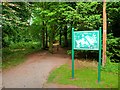
6

A Path in Arrowe Country Park
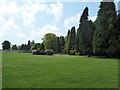
Arrowe Park (also known as Arrowe Country Park) is an area of parkland, woodland and leisure facilities to the west of Birkenhead within the Metropolitan Borough of Wirral. The park comprises approximately 425 acres of land which was a country estate sold to Birkenhead Corporation by Lord Leverhulme in 1926.
Image: © David Dixon
Taken: 6 Sep 2015
0.10 miles
7
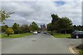
Main driveway
Looking along the main driveway in Landican Cemetery and Crematorium.
Image: © DS Pugh
Taken: 30 Aug 2016
0.11 miles
8
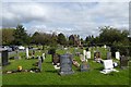
Graves in Landican Cemetery
Looking at some of the graves in one of the spokes of gardens surrounding the crematorium.
Image: © DS Pugh
Taken: 30 Aug 2016
0.12 miles
9
Arrowe Country Park, Birkenhead
Arrowe Park (also known as Arrowe Country Park) is an area of parkland, woodland and leisure facilities to the west of Birkenhead within the Metropolitan Borough of Wirral. The park comprises approximately 425 acres of land which was a country estate sold to Birkenhead Corporation by Lord Leverhulme in 1926.
Image: © David Dixon
Taken: 6 Sep 2015
0.13 miles