IMAGES TAKEN NEAR TO
Fender Court, WIRRAL, CH49 5LH
Introduction
This page details the photographs taken nearby to Fender Court, CH49 5LH by members of the Geograph project.
The Geograph project started in 2005 with the aim of publishing, organising and preserving representative images for every square kilometre of Great Britain, Ireland and the Isle of Man.

There are currently over 7.5m images from over14,400 individuals and you can help contribute to the project by visiting https://www.geograph.org.uk
Image Map (Loading...)


Getting Data...Please wait
Leaflet Map data © OpenStreetMap
Images are licensed for reuse under creativecommons.org/licenses/by-sa/2.0
Notes
- Clicking on the map will re-center to the selected point.
- The higher the marker number, the further away the image location is from the centre of the postcode.
Image Listing (14 Images Found)
Images are licensed for reuse under creativecommons.org/licenses/by-sa/2.0
Image
Details
Distance
1
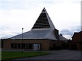
St. Michael & All Angels Church, New Hey Road, Woodchurch
Similar to Hope Street in Liverpool, the RC & CofE churches are at opposite ends of Home Farm Road. Known locally as 'The Tin Church', not just because of its modernist design, but also as a friendly inter-denominational quip to 'The Wood Church' up the hill. The church is visible from junction 3 of the M53.
Image: © El Pollock
Taken: 22 Jul 2009
0.04 miles
2
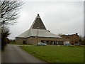
St. Michael and All Angels Catholic Church, Woodchurch
A modern Catholic church which was built in 1965. For more information visit http://homepage.ntlworld.com/s.goulding/index.html
Image: © David Quinn
Taken: 15 Mar 2008
0.06 miles
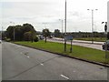
4
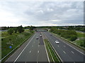
M53 Motorway northbound
View from the bridge on the A552.
Image: © JThomas
Taken: 15 Jun 2019
0.09 miles
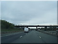
5
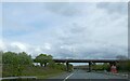
Over and Under
The point at which the A552 from Arrowe Park begins to fly-over the M53 at junction 3 near Woodchurch.
Image: © Roger May
Taken: 30 Aug 2005
0.12 miles

8
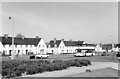
Home Farm Road, Woodchurch ? 1966
Woodchurch Estate was the first and largest of Birkenhead's post-WW2 housing estates, commenced in 1946, and designed with plenty of open space, particularly along the main arteries like Home Farm Road.
Image: © Alan Murray-Rust
Taken: 14 May 1966
0.18 miles
9
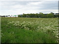
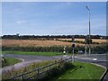
Oilseed rape crop near Landican
Off Landican Lane.
Image: © JThomas
Taken: 15 Jun 2019
0.21 miles
10
Landican Lane off Woodchurch Road Woodchurch
Unusual signpost at end of lane, what does it indicate I wonder? Answers gratefully received!
Image: © Raymond Knapman
Taken: 6 Sep 2012
0.21 miles