IMAGES TAKEN NEAR TO
Conway Close, CHESTER, CH4 8UJ
Introduction
This page details the photographs taken nearby to Conway Close, CH4 8UJ by members of the Geograph project.
The Geograph project started in 2005 with the aim of publishing, organising and preserving representative images for every square kilometre of Great Britain, Ireland and the Isle of Man.

There are currently over 7.5m images from over14,400 individuals and you can help contribute to the project by visiting https://www.geograph.org.uk
Image Map
Images are licensed for reuse under creativecommons.org/licenses/by-sa/2.0
Notes
- Clicking on the map will re-center to the selected point.
- The higher the marker number, the further away the image location is from the centre of the postcode.
Image Listing (16 Images Found)
Images are licensed for reuse under creativecommons.org/licenses/by-sa/2.0
Image
Details
Distance
1

Red sun effect above Saltney
Apparently this unusual red effect was caused by the remnants of Hurricane Ophelia pulling in tropical air and dust from the Sahara. A few minutes later the clouds moved in and the sun disappeared completely.
Image: © John S Turner
Taken: 16 Oct 2017
0.08 miles
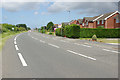
2
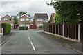
Padarn Close, Saltney
Padarn Close is a cul-de-sac leading off Sandy Lane. Although this part of Saltney lies just over the Welsh border in Flintshire, it is to all intents and purposes a suburb of Chester.
Image: © Stephen McKay
Taken: 14 Jun 2018
0.08 miles
3
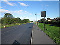
Sandy Lane, Saltney
Heading north towards the A5104 (Chester Road).
Wikipedia http://en.wikipedia.org/wiki/Saltney
Image: © Jeff Buck
Taken: 10 Oct 2013
0.11 miles
4
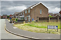
Tegid Way, Saltney
Suburban housing seen from the junction with Sandy Lane.
Image: © Stephen McKay
Taken: 14 Jun 2018
0.12 miles
5

Victoria Road, Saltney
Although most of Saltney is across the Welsh border in Flintshire, it is to all intents and purposes a Chester suburb. Here a Stagecoach bus on route 16 threads its way around the housing estate before returning to Chester bus station. The poster on the rear is advertising an open day at Wrexham Glyndŵr University.
Image: © Stephen McKay
Taken: 14 Jun 2018
0.16 miles
6
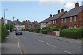
Victoria Road, Saltney
Seen from the junction with Boundary Lane. This is actually in Wales, albeit only just, but the locals are evidently supporting England in the World Cup which was due to start in Russia later the same day.
Image: © Stephen McKay
Taken: 14 Jun 2018
0.17 miles
7
Sandy Lane, Saltney
Seen from the junction with Boundary Lane. Broad and straight, Sandy Lane seems out of keeping with other roads in Saltney - the explanation for this anomaly is given here: Image
Image: © Stephen McKay
Taken: 14 Jun 2018
0.17 miles
8
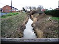
Balderton Brook
Viewed from the modern footbridge, near the old sandstone bridge, the banks of Balderton Brook have just had a trim. Although it doesn't look very impressive here, the brook is a very important part of the drainage system of what were once the Saltney marshes, and it is maintained accordingly.
Image: © John S Turner
Taken: 21 Feb 2007
0.20 miles
9
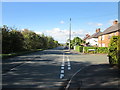
Boundary Lane, Saltney
Taken at the junction with Kinnerton Close. As the name suggests, Boundary Lane runs along the English/Welsh border.
Wikipedia http://en.wikipedia.org/wiki/Saltney
Image: © Jeff Buck
Taken: 10 Oct 2013
0.21 miles
10
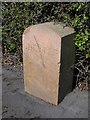
Modern Boundary Marker by Boundary Lane, Saltney, Chester Parish
Parish Boundary Marker by the UC road, in parish of Chester (Chester District), Boundary Lane Saltney, in front of No 118. Adjacent to MSSid: CH_CHES03pb Image
Inscription reads:- : CHESTER / 1998 :
Surveyed
Milestone Society National ID: CH_CHES01pb
Image: © John S Turner
Taken: 7 Apr 2009
0.22 miles