IMAGES TAKEN NEAR TO
Bramhall Close, WIRRAL, CH48 8BP
Introduction
This page details the photographs taken nearby to Bramhall Close, CH48 8BP by members of the Geograph project.
The Geograph project started in 2005 with the aim of publishing, organising and preserving representative images for every square kilometre of Great Britain, Ireland and the Isle of Man.

There are currently over 7.5m images from over14,400 individuals and you can help contribute to the project by visiting https://www.geograph.org.uk
Image Map (Loading...)


Getting Data...Please wait
Leaflet Map data © OpenStreetMap
Images are licensed for reuse under creativecommons.org/licenses/by-sa/2.0
Notes
- Clicking on the map will re-center to the selected point.
- The higher the marker number, the further away the image location is from the centre of the postcode.
Image Listing (4 Images Found)
Images are licensed for reuse under creativecommons.org/licenses/by-sa/2.0
Image
Details
Distance
2
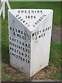
Old Milepost by the A540, Grange, West Kirby
Cast iron post by the A540, in parish of HOYLAKE (WIRRAL District), just South of Gourleys Lane, on the verge beside tarmac, on North East side of road. Cast iron CCC1896, erected by the County Council in the 19th century.
Inscription reads:-
: HESWALL / 4 MILES / GAYTON 4¾ / PARKGATE 7½ / NESTON 7½ / CHESTER 17 : : CHESHIRE / 1896 / COUNTY COUNCIL : : WEST KIRBY / 1 MILE :
Maker:-
: W H SMITH & CO / MAKER / WHITCHURCH :
Merseyside HER.
https://www.heritagegateway.org.uk/Gateway/Results_Single.aspx?uid=3314286&resourceID=1970
Milestone Society National ID: CH_WKCH01
Image: © J Higgins
Taken: 1 Jul 2004
0.18 miles
3
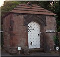
Fleck Lane
Former Well house constructed mid 19th Century. Used to store water before the opening of water works, 1877 on Column Road.
Image: © J Scott
Taken: 4 Aug 2011
0.20 miles
4

Red Rush
The Dee Estuary from the Mariner's Column close to Caldy Hill.
Image: © J Scott
Taken: 5 Nov 2006
0.24 miles