IMAGES TAKEN NEAR TO
Leigh Road, WIRRAL, CH48 5DZ
Introduction
This page details the photographs taken nearby to Leigh Road, CH48 5DZ by members of the Geograph project.
The Geograph project started in 2005 with the aim of publishing, organising and preserving representative images for every square kilometre of Great Britain, Ireland and the Isle of Man.

There are currently over 7.5m images from over14,400 individuals and you can help contribute to the project by visiting https://www.geograph.org.uk
Image Map (Loading...)


Getting Data...Please wait
Leaflet Map data © OpenStreetMap
Images are licensed for reuse under creativecommons.org/licenses/by-sa/2.0
Notes
- Clicking on the map will re-center to the selected point.
- The higher the marker number, the further away the image location is from the centre of the postcode.
Image Listing (15 Images Found)
Images are licensed for reuse under creativecommons.org/licenses/by-sa/2.0
Image
Details
Distance
1
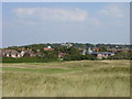
Grange Hill and Royal Liverpool Golf Links
Looking across the Royal Liverpool Golf Links to Grange Hill, West Kirby, the war memorial can be seen on the skyline to the left and to the right the Mariners' column.
Image: © Sue Adair
Taken: 17 Aug 2005
0.05 miles
2
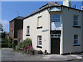
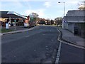
De Grouchy Street
De Grouchy Street (on the left) is the only 'Street' in West Kirby.
Image: © Peter Craine
Taken: 7 Jun 2006
0.09 miles
3
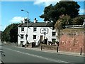
The White Lion public house in Grange Road
Image: © Raymond Knapman
Taken: 9 Sep 2009
0.09 miles
5

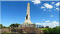
Grange Hill Triangulation Pillar
Located at 52 metres.
Image: © David Quinn
Taken: 22 Dec 2007
0.12 miles
6
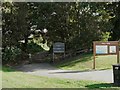
Entrance to the Linear Park off Grange Road
Image: © Raymond Knapman
Taken: 9 Sep 2009
0.18 miles
7
West Kirby Joint railway station (site), Wirral
Opened in 1886 by the Birkenhead Joint Railway (part of both the Great Western Railway and London & North Western Railway) as the terminus of the line from Hooton, this station closed to passengers in 1956 and completely in 1962.
View south east towards Kirby Park and Hooton along the platform site. The distant trees in the centre mark the start of a footpath along the old railway formation.
Image: © Nigel Thompson
Taken: 1 Jan 2019
0.19 miles
8
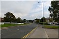
Looking along Orrysdale Road
Looking towards the petrol station near West Kirby station.
Image: © DS Pugh
Taken: 15 Sep 2014
0.20 miles
9
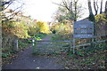
West Kirby entrance to the Wirral Country Park
The entrance to the Wirral Country Park and the Wirral Way at Grange Road, West Kirby.
Wikipedia https://en.wikipedia.org/wiki/Wirral_Country_Park
Image: © Jeff Buck
Taken: 24 Nov 2016
0.20 miles
10
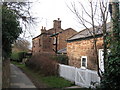
Willow Cottage, West Kirby
Willow Cottage, also known as the Red House as it is constructed entirely of local red sandstone blocks, is one of the oldest houses in West Kirby.
Image: © Sue Adair
Taken: 30 Jan 2008
0.20 miles