IMAGES TAKEN NEAR TO
Lache Lane, CHESTER, CH4 7LX
Introduction
This page details the photographs taken nearby to Lache Lane, CH4 7LX by members of the Geograph project.
The Geograph project started in 2005 with the aim of publishing, organising and preserving representative images for every square kilometre of Great Britain, Ireland and the Isle of Man.

There are currently over 7.5m images from over14,400 individuals and you can help contribute to the project by visiting https://www.geograph.org.uk
Image Map
Images are licensed for reuse under creativecommons.org/licenses/by-sa/2.0
Notes
- Clicking on the map will re-center to the selected point.
- The higher the marker number, the further away the image location is from the centre of the postcode.
Image Listing (14 Images Found)
Images are licensed for reuse under creativecommons.org/licenses/by-sa/2.0
Image
Details
Distance
1
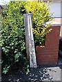
Old Boundary Marker by Lache Lane, Marlston Cum Lache
County Boundary Marker by the UC road, in parish of Marlston Cum Lache (Chester District), Lache Lane, against brick wall on the pavement, Northwest side of road. Opposite Greenacre Road and Boundary Marker: CH_CHECO04cb Image
Inscription reads vertically:-
: CHESHIRE COUNTY COUNCIL : : CITY OF CHESTER :
To be surveyed
Milestone Society National ID: CH_CHECO03cb
Image: © Milestone Society
Taken: Unknown
0.02 miles
2
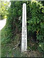
Old Boundary Marker by Lache Lane, Marlston cum Lache
County Boundary Marker by the UC road, in parish of Marlston Cum Lache (Chester District), Lache Lane, on verge at junction with Greenacre Road, South East side of road. Opposite Boundary Marker: CH_CHECO03cb Image
Inscription reads vertically:-
: CITY OF CHESTER : : CHESHIRE COUNTY COUNCIL :
To be surveyed
Milestone Society National ID: CH_CHECO04cb
Image: © Milestone Society
Taken: Unknown
0.03 miles
3
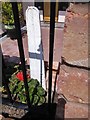
Old Boundary Marker by Green Lane, Lache, Chester Castle Parish
County Boundary Marker by the UC road, in parish of Chester Castle (Chester District), Green Lane, just West of the junction with Lache Lane, in garden, partly buried in border wall. Directly opposite Boundary Post:- CH_CHECO01cb Image
The only inscription visible is:-
COUNCIL
To be surveyed
Milestone Society National ID: CH_CHECO02cb
Image: © Milestone Society
Taken: Unknown
0.10 miles
4
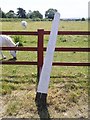
Old Boundary Marker by Green Lane, Lache, Chester Castle Parish
County Boundary Marker by the UC road, in parish of Chester Castle (Chester District), Green Lane, just West of junction with Lache Lane, against field fence.
To be surveyed
Milestone Society National ID: CH_CHECO01cb
Image: © Milestone Society
Taken: Unknown
0.11 miles
5
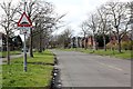
Circular Drive, Lache
Wikipedia http://en.wikipedia.org/wiki/Lache
Image: © Jeff Buck
Taken: 24 Feb 2014
0.12 miles
6
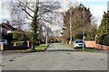
Whaddon Drive, Lache
Wikipedia http://en.wikipedia.org/wiki/Lache
Image: © Jeff Buck
Taken: 24 Feb 2014
0.16 miles
7
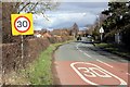
Lache Lane
Lache Lane entering the Lache. I get the impression this could be a 30mph zone.
Wikipedia http://en.wikipedia.org/wiki/Lache
Image: © Jeff Buck
Taken: 24 Feb 2014
0.18 miles
8
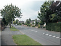
Westminster Park
South Chester suburb.
Image: © Dennis Turner
Taken: 18 Aug 2005
0.18 miles
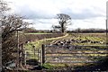
9
Horse and Donkey Sanctuary
Located on farmland off Lache Lane to the south of Chester.
Image: © Dennis Turner
Taken: 18 Aug 2005
0.18 miles
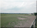
10
Footpath and field off Lache Lane
On the map this path appears to lead towards the park and ride on the A483 (Wrexham Road).
Image: © Jeff Buck
Taken: 24 Feb 2014
0.20 miles