IMAGES TAKEN NEAR TO
Sandbrook Lane, WIRRAL, CH46 0QN
Introduction
This page details the photographs taken nearby to Sandbrook Lane, CH46 0QN by members of the Geograph project.
The Geograph project started in 2005 with the aim of publishing, organising and preserving representative images for every square kilometre of Great Britain, Ireland and the Isle of Man.

There are currently over 7.5m images from over14,400 individuals and you can help contribute to the project by visiting https://www.geograph.org.uk
Image Map
Images are licensed for reuse under creativecommons.org/licenses/by-sa/2.0
Notes
- Clicking on the map will re-center to the selected point.
- The higher the marker number, the further away the image location is from the centre of the postcode.
Image Listing (7 Images Found)
Images are licensed for reuse under creativecommons.org/licenses/by-sa/2.0
Image
Details
Distance
1
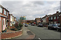
Croft Drive, Moreton
Housing on Croft Drive, Moreton, with a high-rise tower block undergoing renovation visible in the distance.
Image: © William Starkey
Taken: 17 Mar 2013
0.09 miles
2
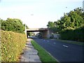
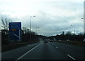
The Motorway Bridge, Manor Drive, Upton
The M53, Junction 2A. Moreton Spur motorway bridge crosses over Manor Drive in Upton.
Image: © El Pollock
Taken: 15 Jul 2009
0.17 miles
3
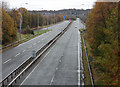
Spured On
Moreton Spur of M53 from bridge on Upton Road.
Image: © J Scott
Taken: 14 Nov 2010
0.17 miles
4
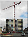
Demolition of high rise tower block
Demolition work in progress on a high rise tower block in Moreton.
Image: © William Starkey
Taken: 17 Mar 2013
0.19 miles
6
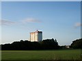
A Block of Flats, Moreton
The block of flats in Chapelhill Road, Moreton. The picture is taken from Upton Park.
Image: © El Pollock
Taken: 15 Jul 2009
0.22 miles
7
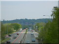
Moreton Spur
Moreton Spur from the roadbridge, the Bidston ridge in view, with the lighthouse and Observatory in the photo
Image: © Mihacel
Taken: 14 May 2021
0.23 miles