IMAGES TAKEN NEAR TO
Vyner Road, WALLASEY, CH45 6TE
Introduction
This page details the photographs taken nearby to Vyner Road, CH45 6TE by members of the Geograph project.
The Geograph project started in 2005 with the aim of publishing, organising and preserving representative images for every square kilometre of Great Britain, Ireland and the Isle of Man.

There are currently over 7.5m images from over14,400 individuals and you can help contribute to the project by visiting https://www.geograph.org.uk
Image Map
Images are licensed for reuse under creativecommons.org/licenses/by-sa/2.0
Notes
- Clicking on the map will re-center to the selected point.
- The higher the marker number, the further away the image location is from the centre of the postcode.
Image Listing (9 Images Found)
Images are licensed for reuse under creativecommons.org/licenses/by-sa/2.0
Image
Details
Distance
2
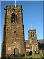
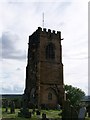
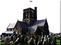
St Hilary's - A Church With Two Towers
The tower bears the date 1530, the rest of the church having been rebuilt in 1760 using stone from the previous building. In 1857 the church was destroyed by fire shortly after extensive restoration. The blaze was caused by a fire lit to warm the congregation on a particularly cold winter's evening being enthusiastically stoked, causing the fat on the bacon sides hanging in the church tower to melt which then ignited the wooden floorboards, adding to the conflagration. It is told that the town of Wallasey smelt of bacon for days afterwards!
Image: © Sue Adair
Taken: 9 Jan 2008
0.19 miles
3

St. Hilary's Church, Wallasey
A church with a double tower. As viewed from Cross Lane nature reserve.
Image: © El Pollock
Taken: 22 Jul 2009
0.19 miles
4
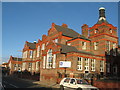
St George's Primary School, Wallasey
St George's Primary School was built in 1907.
Image: © Sue Adair
Taken: 9 Jan 2008
0.19 miles
7
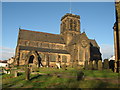
St Hilary's, Wallasey
St Hilary's is the church on the sandstone outcrop high above Wallasey Village. It is thought to have been the site of a church since the 6th century and has been rebuilt many times, the present building dates from 1858-9, the previous church having burnt down in 1857. The stone was donated from Rake Lane quarry.
Image: © Sue Adair
Taken: 9 Jan 2008
0.21 miles
8
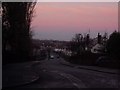
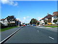
Taunton Road
Wallasey Sandhills are seen in the background. The skyscape is absolutely amazing here with the pinks, the reds and the blues all merging into one.
Image: © russ
Taken: Unknown
0.23 miles
9
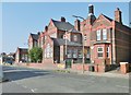
Wallasey, primary school
St. George's Primary School, on St. George's Road: http://www.stgeorges.wirral.sch.uk/
Image: © Mike Faherty
Taken: 4 Jul 2018
0.24 miles