IMAGES TAKEN NEAR TO
Bidston Moss, WALLASEY, CH44 2HE
Introduction
This page details the photographs taken nearby to Bidston Moss, CH44 2HE by members of the Geograph project.
The Geograph project started in 2005 with the aim of publishing, organising and preserving representative images for every square kilometre of Great Britain, Ireland and the Isle of Man.

There are currently over 7.5m images from over14,400 individuals and you can help contribute to the project by visiting https://www.geograph.org.uk
Image Map
Images are licensed for reuse under creativecommons.org/licenses/by-sa/2.0
Notes
- Clicking on the map will re-center to the selected point.
- The higher the marker number, the further away the image location is from the centre of the postcode.
Image Listing (26 Images Found)
Images are licensed for reuse under creativecommons.org/licenses/by-sa/2.0
Image
Details
Distance
2
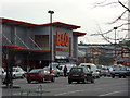
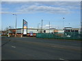
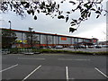
Do It Yourself
Entrance to B & Q superstore, Wallasey.
Image: © J Scott
Taken: 12 Nov 2010
0.05 miles
4
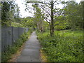
Footpath north of Bidston (3)
Linking Bidston station with the outskirts of Wallasey. The railway line to New Brighton is on the other side of the fence.
Image: © Richard Vince
Taken: 1 Jun 2019
0.08 miles
6
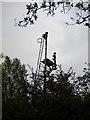
Bracket signal post north of Bidston
Glimpsed through the vegetation alongside a footpath, this bracket signal would once have controlled the junction at which the Seacombe branch diverged from the railway line to New Brighton. The latter line is still open; it is somewhat surprising that this signal post has been left rusting next to it.
Image: © Richard Vince
Taken: 1 Jun 2019
0.08 miles
7
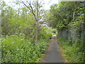
Footpath north of Bidston (2)
Linking Bidston station with the outskirts of Wallasey. The railway line to New Brighton is on the other side of the fence.
Image: © Richard Vince
Taken: 1 Jun 2019
0.09 miles
8
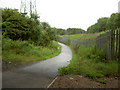
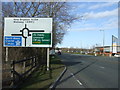
Cycle-path to Wallasey
Part of the National Cycle Network route 56 between Liverpool and Chester. Photo was taken from underneath the road bridge.
Image: © David Quinn
Taken: 20 Jul 2007
0.09 miles
9
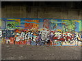
Graffiti
Located on the National Cycle Network underneath the road bridge.
Image: © David Quinn
Taken: 20 Jul 2007
0.13 miles
10
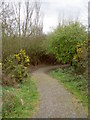
Bidston Moss Nature Reserve
A small nature reserve of approximately 8 hectares located in between The Birket, the M53 motorway and the A554 dual-carriageway. Set up as a nature reserve in 1994, the main aims are,
"to conserve and enhance the wetland as a rich wildlife habitat, to allow natural succession from rough grassland to scrub on the drier areas; to encourage the use of the area by local schools; to raise public awareness of the Reserve and to protect and maintain a safe site suitable for informal recreation."
The Reserve is supported by Wirral Council, Friends of Bidston Moss, the Mersey Forest, the BTCV, and Groundwork Wirral.
Image: © David Quinn
Taken: 16 Mar 2008
0.14 miles